アプリオンは、世界のアプリランキングや口コミから、おすすめアプリをまとめている人気アプリ探しサイトです。

NavLink US [iPhone]

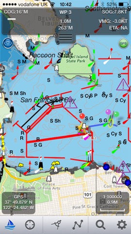
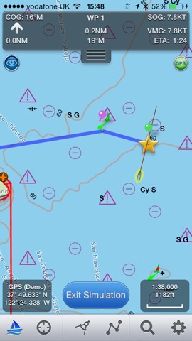
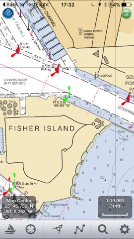
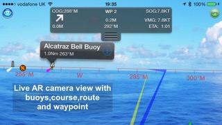
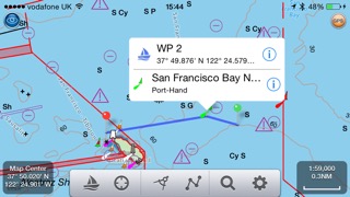
DigitalYacht Ltd.が配信するiPhoneアプリ「NavLink US」の評価や口コミやランキング推移情報です。このアプリには「ナビゲーション」「旅行」などのジャンルで分類しています。APPLIONでは「NavLink US」の他にもあなたにおすすめのアプリのレビューやみんなの評価や世界ランキングなどから探すことができます。

NavLink USのおすすめ画像1
NavLink USのおすすめ画像2
NavLink USのおすすめ画像3
NavLink USのおすすめ画像4
NavLink USのおすすめ画像5
<
>

DigitalYacht Ltd.の地図/ナビアプリ

「NavLink US」は、DigitalYacht Ltd.が配信する地図/ナビアプリです。

ナビゲーション 旅行

このアプリの話題とニュース

  • 新バージョン5.3.5が配信開始。新機能や改善アップデートがされています。


  • 2014年2月22日(土)にiPhoneとiPad両対応のユニバーサルアプリとしてリリース!


最新更新情報

version5.3.5が、2021年9月17日(金)にリリース

Much much faster chart drawing on newer Apple devices ( iPhone 9 and later and iPad 6th gen and later)

Support for iOS Dark mode - better for night time vision and use.

NavLink iOS and its charts now works on the new MacBook M1.

Cardinal mark light patterns now displayed correctly in light details

NMEA instrument support for depth added and split screen iPad instruments view for wind and depth.

Improvements to seamless chart coverage

Improvements to In App Purchase experience

Fix for charts not drawing if no internet after fresh launch of the app

使い方や遊び方

Marine Navigation App that turns your Apple Device in to a full function chart plotter. Features include:


· Realtime GPS position plotted on Marine charts derived from NOAA data (Vector (ENC) & Raster (RNC))


· AIS overlay when connected to compatible wireless AIS system


· Waypoints & routes with full route editing and planning function


· Position, COG, SOG, VMG, bearing, distance & ETA displays


· Configurable chart layers


· HorizonView overlays navaid and targets onto iPad/Phone camera display


· Automatic free chart updates included for 1 year


· Weather buoy data


· A-B chart ruler for quick & easy bearing and distance measurement


· All NOAA US charts are included in the price


· Optional in-app purchase of CA charts


AIS Functionality
When connected to an AIS system via a wireless NMEA link, NavLink will provide a real time overlay of AIS targets and CPA and TCPA alarms. Internet AIS requires Boat Beacon app


HorizonView
Overlay chart & AIS objects on the iPhone or iPad camera image to create an augmented HorizonView display, that makes Nav-Aid & vessel identification simple and reliable


Plan & sail routes
Instant route and waypoint creation by tapping on screen. Route reverse function and route overview with inter-leg bearing and distance. Share your routes via dropbox and email with other users


NavLink Charting
NavLink utilises the latest S57 based NOAA digital mapping & features automatic free updates for 1 year. With vector mapping, you can manage your layers of data to de-clutter the screen or maximise information. NavLink supports all key charting feature such as buoys, lights, bridges, depth contours, spot depths, depth contours, anchorage & military areas, weather buoys


Interfacing
NavLink is compatible with all Digital Yacht's wireless NMEA devices such as the iAIS, WLN10, WLN10HS, NavLink, iNavHub & PilotLink that stream wireless AIS data to your Apple device


If you have a WiFi-only iPad you will need an external Bluetooth GPS receiver to enable navigation. 3rd Party units are available such as the Garmin Glo.


Please note: Continued use of GPS running in the background can dramatically decrease battery life


Subscriptions
Your purchase includes 12 months free updates to the included chart set. At the end of the 12 month period continued access to ongoing chart updates is available via an in-app purchase. Charts for other regions may also be added to your product via optional in-app purchase.


Our in-app purchases are 1 year subscriptions, which automatically renew at the end of the subscription period unless auto-renew is turned off at least 24-hours before the end of the current period. Payment will be charged to your iTunes Account at confirmation of purchase, and will be charged for renewal within 24-hours prior to the end of the current period. Pricing for our 1 year US Charts update subscription is $9.99.


Subscriptions may be managed by the iTunes account holder and auto-renewal may be turned off by going to Account Settings after purchase. 
No cancellation of the current subscription is allowed during active subscription period.


Privacy policy:- http://seanav.net/digitalyacht/privacy.php
Terms and conditions:- http://seanav.net/dyiostsandcs.php


Safety Notice
NavLink & the charts are intended to be used as an aid to navigation. Only official government charts and notice to mariners contain all of the current information needed for safe navigation. This product's features cannot be relied on to be complete or accurate and may vary locally. It is the Captain's or Boat Owner's responsibility to use official government charts, notice to mariners, caution, sound judgement and proper navigational skill when operating their vessel and using this or any other Digital Yacht product.


By purchasing this App, you are accepting the limitations of this app and the NOAA charts.


Third Party Licenses and Notices
NOTICE: US Marine Charts are derived from official NOAA Electronic Navigational Charts.

最新ストアランキングと月間ランキング推移

NavLink USのiPhoneアプリランキングや、利用者のリアルな声や国内や海外のSNSやインターネットでの人気状況を分析しています。

基本情報

仕様・スペック

対応OS
11.0 以降
容量
31.4 M
推奨年齢
全年齢
アプリ内課金
あり
更新日
2021/09/17

リリース日
2014/02/22

集客動向・アクティブユーザー分析

オーガニック流入


アクティブ率


※この結果はNavLink USのユーザー解析データに基づいています。

アプリ内課金の売れ筋ランキング

  • 1位: Weather charts (880円)

  • 2位: Canadian Charts (3600円)

  • 3位: UK Charts (2000円)

  • 4位: US Chart Updates (3000円)

利用者の属性・世代

アプリ解析デモグラフィックデータ(男女年代比率52%)

聞いてないよォ

デモグラフィックデータを元にユーザー層の性別や年齢分布などを考慮して推定しています。

ネット話題指数

開発会社の配信タイトル

このアプリと同一カテゴリのランキング

ペーパーマリオRPG
任天堂
amazon

DigitalYacht Ltd. のアプリ

DigitalYacht Ltd. の配信アプリ >

新着おすすめアプリ

新着おすすめアプリ >

注目まとめ

iPhoneアプリまとめ >