アプリオンは、世界のアプリランキングや口コミから、おすすめアプリをまとめている人気アプリ探しサイトです。

BRMB Maps by Backroad Maps [iPhone]

Mussio Ventures Ltd.が配信するiPhoneアプリ「BRMB Maps by Backroad Maps」の評価や口コミやランキング推移情報です。このアプリには「ナビゲーション」「旅行」などのジャンルで分類しています。APPLIONでは「BRMB Maps by Backroad Maps」の他にもあなたにおすすめのアプリのレビューやみんなの評価や世界ランキングなどから探すことができます。

BRMB Maps by Backroad Mapsのおすすめ画像1
BRMB Maps by Backroad Mapsのおすすめ画像2
BRMB Maps by Backroad Mapsのおすすめ画像3
BRMB Maps by Backroad Mapsのおすすめ画像4
BRMB Maps by Backroad Mapsのおすすめ画像5
BRMB Maps by Backroad Mapsのおすすめ画像6
BRMB Maps by Backroad Mapsのおすすめ画像7
BRMB Maps by Backroad Mapsのおすすめ画像8
BRMB Maps by Backroad Mapsのおすすめ画像9
BRMB Maps by Backroad Mapsのおすすめ画像10
<
>

Mussio Ventures Ltd.の地図/ナビアプリ

「BRMB Maps by Backroad Maps」は、Mussio Ventures Ltd.が配信する地図/ナビアプリです。

ナビゲーション 旅行

このアプリの話題とニュース

  • 新バージョン2.4.0が配信開始。新機能や改善アップデートがされています。(12/16)


  • 2020年10月8日(木)にiPhoneとiPad両対応のユニバーサルアプリとしてリリース!


最新更新情報

version2.4.0が、2023年12月16日(土)にリリース

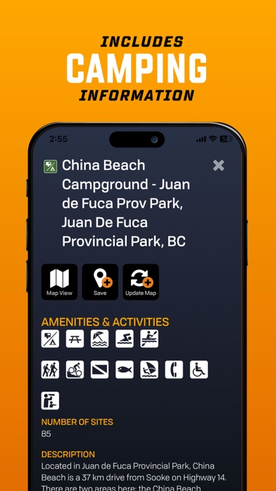
Version 2.4 includes a major update of all basemap and Adventure information, bringing in all of the
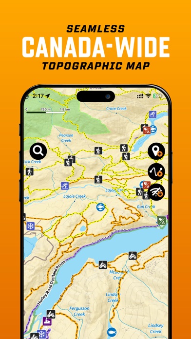
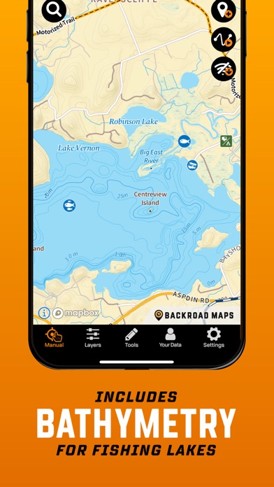
changes and updates over the last year. The basemap has over 22,000 km of new and updated roads plus over 8,000 new land and water features. The Adventures includes over 20,000 km of new and updated ATV/Overland/Snowmobile, Multi-Use/Mountain Bike and Paddling Routes and Trails. There are also 5,400 new Adventure POI added. We were also able to fit in a new Quick Start track recording as well as new colour line styles to help differentiate the various recorded tracks by activity.

Version 2.4 Highlights:

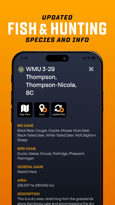
- Includes hundreds of customer Map and POI Updates from the 30th  Anniversary Contest

- Includes tens of thousands of km of new roads, thousands of km of new ATV and snowmobile
routes, multi-use and bike trails, paddling routes and more.

- Includes over 8,000 new Land and Water features

- Includes almost 5,500 new Adventure POIs

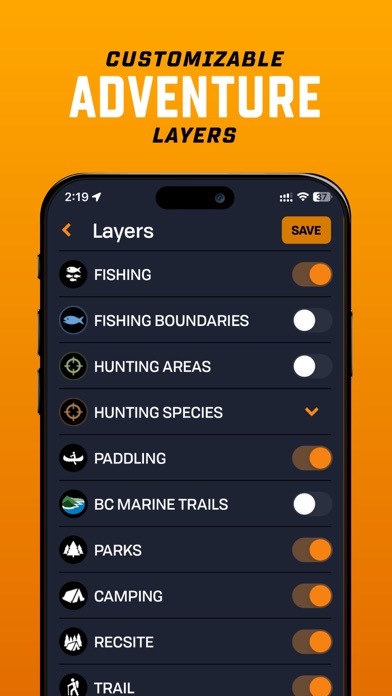
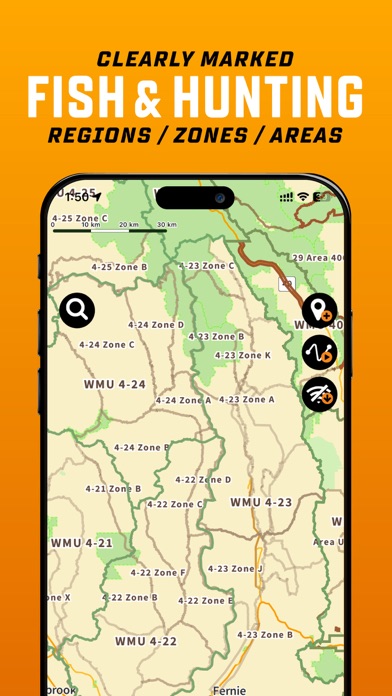
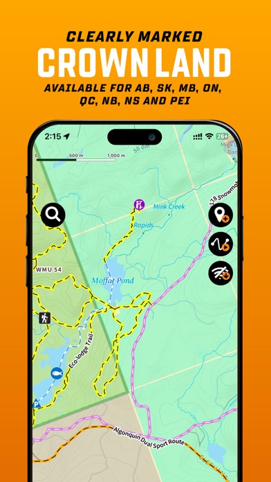
- Enhanced Private/Crown Land, Industry/Rec Roads, Oil &amp; Gas, Service Providers, Gas Stations and EV Charging Overlays
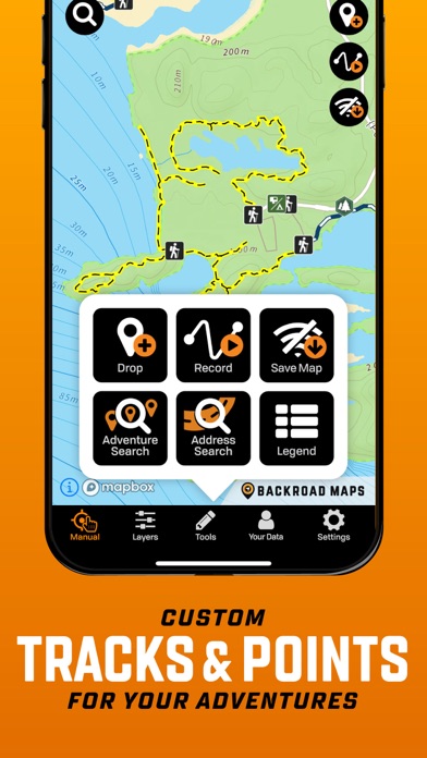
- Autofill date/time and activity to help start recording your tracks quicker
- Track lines are now coloured by outdoor activity to help you differentiate between your favourite activities

Version 2.4 Update Stats:
- 17,000+ km of various roads & highways
- 5,000 km of new or enhanced Logging Roads
- 10,000 km of additional ATV Trails
- 1,500 km of Overland Routes
- 650 km of new Snowmobile Trails
- 6,000 km of new and updated Multi-use Trails
- 250 km of new Mountain Bike Trails
- 2,000 km of new and enhanced Paddling Routes

- 8,000 new Land & Water features POIs

- 5,400 more Adventure POIs

使い方や遊び方

Experience the Great Outdoors of Canada in a whole new way with BRMB Maps' top-rated backcountry maps. Our industry-leading road and trail maps cover all of Canada, and our Smartphone App and Web Map let you research, plan and navigate with ease – even offline! Our maps are complemented with thousands of points of interest for outdoor recreation, including hunting, fishing, camping, hiking, biking, canoeing, kayaking, ATVing, snowmobiling, skiing, snowshoeing, and wildlife viewing. Plus, our descriptions and data are unlike anything you will find in other mapping apps, making BRMB Maps the ultimate tool for backcountry exploration.


The BRMB Maps App is a one stop guide, allowing for safe and easy navigation into and out of the Canada’s backcountry:
View your current location on the map and track your route
The fast, seamless map interface allows you so see all the roads, parks, and geographic features from the popular Backroad Mapbooks series across the entire country.
Reveal the lay of the land with topographic contours and relief shading
Explore lakes like never before with bathymetric (lake depths) contours
Zoom in and see all the logging, industrial and other roads not found on other maps
View on multiple devices, such as smartphone tablet or computer, with a single account


GET MORE WITH BRMB MAPS PRO
Download offline maps - track your exact GPS location as you navigate the trail, even when you don’t have a signal
Save All the info offline - even Point of Interest information & descriptions
Access current, high resolution satellite map imagery
Adventure Layers revealing thousand’s of Points of Interest within each Adventure Layer providing descriptions, access, trail info, fish and hunt species, and so much more
Access Crown Land and Private Land Layers
Access the Resource and Recreation Road layer to overlay on the satellite imagery
Record your Adventures & Save your Trips
Get access to the BRMBMAPS.COM website, where you can further plan your trips and explore on a bigger screen
Design and print custom topo maps through brmbmaps.com


Adventure Layers include:
Attractions
- Over 15,000 Attractions, Beaches, Caves, Ghost Towns, Hot Springs, Lighthouses, Museums, Waterfalls, and more
Fishing
- Over 20,000 Lake, River & Creek and Ocean Fishing areas
- Fish Zone Boundaries, Lake Bathymetry, Stocked Lakes, Marinas & Boat Launches
- Fishing descriptions with Species, Lake Stats & Regulation links
Hunting Areas
- Over 2,500 Management Units (WMU/WMZ, etc.), Species Specific Zones, and more
- Hunting descriptions with Species & Regulation links
Paddling Routes
- Almost 3,000 Paddling routes including Access Points & Portages
- Canoe & Kayak, Lake Circuits, River & Ocean Routes and Whitewater
Parks
- Over 35,000 National, Provincial, Regional & Urban parks including Campsites, Picnic Areas, Backcountry Cabins, Conservation Areas, and more
Recreation Sites
- Over 1,300 sites listed with Activities, Size, RV or 4wd Access, and more
Trails
- Over 14,000 Trail tracks with Trailheads for Hiking, Biking, Equestrian, and more
- Trail descriptions including Difficulty, Length and Elevation Gain
ATV Trails
- Almost 1,700 trail tracks with Trailheads for ATV, OHV, Dirtbikes and Overlanding
Snowmobile Routes
- Over 2,250 trail tracks with Trailheads offering Club, Groomed & Backcountry Routes
Wildlife Viewing
- Over 1,750 sites for Birdwatching, Large & Small Animals, Whale Watching, and more
Winter Recreation
- Over 1,900 Trail tracks with Trailheads for Backcountry, Cross-Country & Nordic Skiing, Downhill Areas, and Snowshoeing


BRMB Maps PRO is only $3.49/mo. Payment will be charged to your iTunes account on confirmation. Subscriptions will automatically renew unless cancelled within 24-hours before the end of the current period.
You can turn-off auto-renewal in Settings: http://support.apple.com/kb/ht4098
Our Terms of Use: https://www.brmbmaps.com/terms-conditions
Our Privacy Policy: https://www.brmbmaps.com/privacy-policy

最新ストアランキングと月間ランキング推移

BRMB Maps by Backroad MapsのiPhoneアプリランキングや、利用者のリアルな声や国内や海外のSNSやインターネットでの人気状況を分析しています。

基本情報

仕様・スペック

対応OS
13.0 以降
容量
197 M
推奨年齢
全年齢
アプリ内課金
あり
更新日
2023/12/16

リリース日
2020/10/08

集客動向・アクティブユーザー分析

オーガニック流入


アクティブ率


※この結果はBRMB Maps by Backroad Mapsのユーザー解析データに基づいています。

アプリ内課金の売れ筋ランキング

  • 1位: BRMB Maps PRO (280円)

利用者の属性・世代

アプリ解析デモグラフィックデータ(男女年代比率52%)

ちょっ待てよ

デモグラフィックデータを元にユーザー層の性別や年齢分布などを考慮して推定しています。

ネット話題指数

開発会社の配信タイトル

このアプリと同一カテゴリのランキング

スターバックス プレミアム ソリュブルブラックスティック
スターバックス
amazon

Mussio Ventures Ltd. のアプリ

Mussio Ventures Ltd. の配信アプリ >

新着おすすめアプリ

新着おすすめアプリ >

注目まとめ

iPhoneアプリまとめ >