アプリオンは、世界のアプリランキングや口コミから、おすすめアプリをまとめている人気アプリ探しサイトです。

Fishing Points - Lake Maps [iPhone]

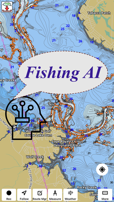
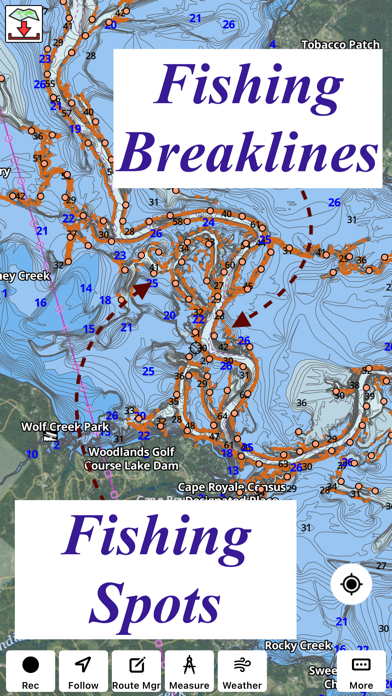
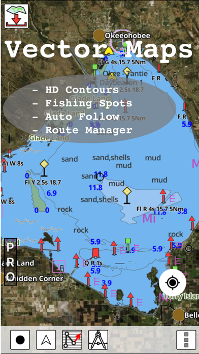
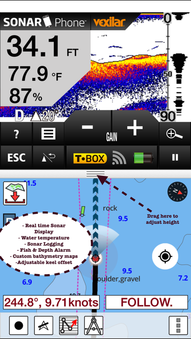
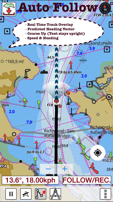
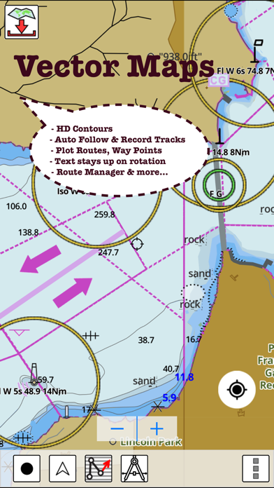
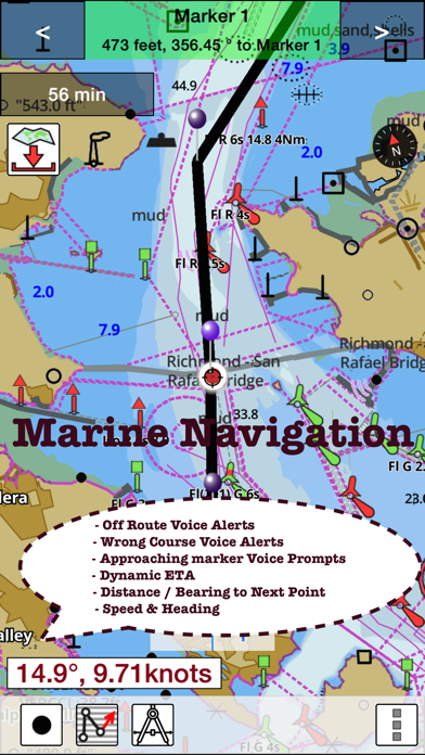
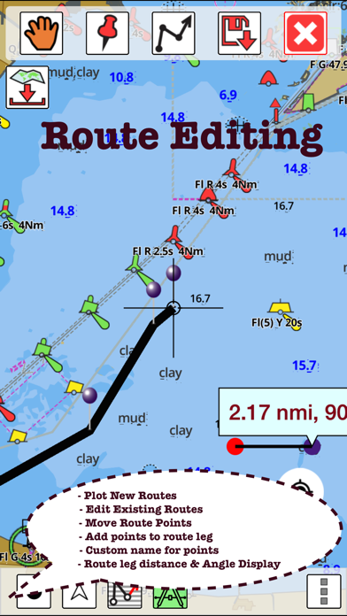
Bist LLCが配信するiPhoneアプリ「Fishing Points - Lake Maps」の評価や口コミやランキング推移情報です。このアプリには「スポーツ」「ナビゲーション」などのジャンルで分類しています。APPLIONでは「Fishing Points - Lake Maps」の他にもあなたにおすすめのアプリのレビューやみんなの評価や世界ランキングなどから探すことができます。

Fishing Points - Lake Mapsのおすすめ画像1
Fishing Points - Lake Mapsのおすすめ画像2
Fishing Points - Lake Mapsのおすすめ画像3
Fishing Points - Lake Mapsのおすすめ画像4
Fishing Points - Lake Mapsのおすすめ画像5
Fishing Points - Lake Mapsのおすすめ画像6
Fishing Points - Lake Mapsのおすすめ画像7
Fishing Points - Lake Mapsのおすすめ画像8
Fishing Points - Lake Mapsのおすすめ画像9
Fishing Points - Lake Mapsのおすすめ画像10
<
>

Bist LLCのスポーツアプリ

「Fishing Points」は、Bist LLCが配信するスポーツアプリです。

スポーツ ナビゲーション

このアプリの話題とニュース

  • 大人の男性スマホユーザーに人気が出てきています。


  • 新バージョン142.0.0が配信開始。新機能や改善アップデートがされています。(4/26)


  • 2017年3月7日(火)にiPhoneとiPad両対応のユニバーサルアプリとしてリリース!


最新更新情報

version142.0.0が、2024年4月26日(金)にリリース

- MAJOR UPDATE

This release has two major upates:
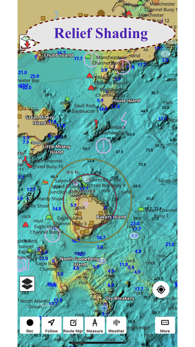
1.) Relief Shading:

i-Boating relief shading is like Google Street View, but for underwater terrain (Sea View). It's a visual representation of what the underwater terrain looks like. If you were to drain the oceans/lakes of all the water, that is the kind of view relief shading attempts to show.

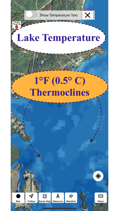
2.) Lake Temperature Maps:

- Lake Temperature maps show variation in temperature accurate to 1 degree fahrenheit (0.5 degree celsius).
- Maps are color coded making it easy to identify lines where the temperature variation starts
- Easy to identify warm areas (to find the best fishing spots)
- Actual temperature text can be toggled on demand
- The application supports showing temperatures in Fahrenheit, Celsius and Kelvin

使い方や遊び方

Only app with Fishing AI to find productive fishing breaklines and fishing spots.  It offers access to Fishing Lake Depth Maps & Marine Charts with fishing points for USA, Canada, UK, etc.  Coverage includes NOAA marine vector charts,freshwater lake maps,USACE inland river maps (HD/1ft bathymetry/Sonar Contours).


First Fishing GPS app to have route assistance with Voice Prompts for marine navigation. You can create new boating routes or import existing GPX/KML routes. It supports Nautical Charts course up orientation. Includes Tide & Currents prediction.


► FISHING AI
Emulates an expert angler. It is trained to include multiple variables.
√ Lake bathymetry/topography
* Point Bars
* Humps / Underwater Islands
* Channels
* Saddles
* Artificial / Man Made Structures
* River Bed
* Ledges
* Side Feeder Streams
* Pits
* And more...
√ Local Knowledge for a lake gained over the years about likely hot spots
√ Weather Patterns
√ Vegetation Maps
√ Fish Type


►FEATURES
√ Beautiful & detailed Hardware/GPU accelerated vector charts (text stays upright on rotation)
√ Long press to query the details of Marine object (Buoy,Lights,Obstruction etc).
√ Customizable depth(Ft/Fathom/Meter) & distance units(km/mi/NM)
√ Customizable Shallow Depth.
√ Record tracks,Autofollow with real-time track overlay & predicted path vector.
√ Voice Prompts for marine navigation (requires GPS )
√ 1ft / 3ft depth contour maps for anglers for selected lake maps.
√ Supports GPX/KML for boating route editing/import.
√ Tide & Currents prediction.
√ Seamless chart quilting of marine charts
√ Enter or import Waypoints.


► MAPS
It includes unlimited updates for 1 year.
√ Lake Maps & Nautical Charts with Fishing Points covering US, UK,Germany, NL, AU etc.


►ROUTE MANAGEMENT / TRIP PLANNING
√ Create New Route/Edit Existing Routes
√ Move Points
√ Add points to an existing route leg
√ Delete / Rename points
√ Import GPX,KML & KMZ files
√ Plot/Edit Routes
√ Enter Waypoints
√ Share/Export Routes,Tracks&Markers
√ Reverse Routes


►GPS FEATURES
√ Auto Follow
* Real Time Track Overlay
* Predicted Path Vector
* Course Up(Text stays upright)
* Speed & Heading
√ Route Assistance With Voice Prompts
* Prompts when approaching a boating route marker
* Continous distance & ETA updates
* Alerts when sailing/boating off route
* Alerts when boating in wrong direction
√ Record Tracks


►TIDE & CURRENTS
* For US, Canada, UK, Germany & New Zealand
* High/Low Tides
* Tidal Current Prediction
* Active Current Stations


► SHARING
* Share tracks/routes/markers on Facebook & Twitter
* Export tracks/routes/markers as compressed GPX files.


Sample Charts
√ KISSIMMEE, Lake Apopka, ISTOKPOGA, SEMINOLE, TOHOPEKALIGA, Lake Tohopekaliga, HARRIS, Lakeocklawaha,
√ East Lake Tohopekaliga, Bighenderson, GRIFFIN, MONROE, TALQUIN, Lake Eustis, EUSTIS, WEOHYAKAPKA,
√ ORANGE , HARNEY, MICCOSUKEE, HATCHINEHA, SANTA FE SWAMP, Farm 13 Stick Marsh, Weir,
√ LOCHLOOSA , Crooked Lake, MARIAN, DEER POINT , HANCOCK, ROSALIE,
√ DORA, POINSETT, CROOKED , SANTA FE , RIVER STYX, Lake Yale,
√ YALE, CYPRESS , Lake Louisa, KERR, ARBUCKLE, PIERCE, June, JACKSON, PANASOFFKEE,
√ ALLIGATOR , DOCTORS , REEDY , OKAHUMPKA SWAMP, Jackson, Forest North, ROUSSEAU, MARION,
√ WASHINGTON, JOHNS , TARPON, Lake Minnehaha, HAMILTON, WOODRUFF, TIGER ,
√ DEXTER, PARKER, SAMPSON, COBB MARSH, Lake Minneola, GENTRY, DORR, BUTLER, Kingsley,
√ WINDER, TRAFFORD, BUFFUM, Josephine, TIBET, CLINCH, OKAHUMPKA,
√ LITTLE SANTA FE , ELOISE, Cherry Lake, BEAUCLAIR, MATTIE, CONWAY, SOUTH ,
√ OTTER SLOUGH, Bigsand, ASHBY, ARIANA, Hampton, CYPRESS CREEK, JULIANA, ,


PLEASE NOTE: Continued use of GPS running in the background can dramatically decrease battery life.

カスタマーレビュー・評価

2.0
5つ星
 
0
4つ星
 
0
3つ星
 
0
2つ星
 
1
1つ星
 
0

最新ストアランキングと月間ランキング推移

Fishing PointsのiPhoneアプリランキングや、利用者のリアルな声や国内や海外のSNSやインターネットでの人気状況を分析しています。

基本情報

仕様・スペック

対応OS
8.0 以降
容量
52.4 M
推奨年齢
全年齢
アプリ内課金
あり
更新日
2024/04/26

リリース日
2017/03/07

集客動向・アクティブユーザー分析

オーガニック流入


アクティブ率


※この結果はFishing Points - Lake Mapsのユーザー解析データに基づいています。

アプリ内課金の売れ筋ランキング

  • 1位: Lithuania - Marine Charts (3000円)

  • 2位: Poland - Marine Charts (3000円)

  • 3位: Iceland - Marine Charts (5000円)

  • 4位: Scotia Sea- Marine Charts (3000円)

  • 5位: Maldives & Sri Lanka (3500円)

  • 6位: Fiji / Vanuatu Islands (3500円)

  • 7位: South China Sea & Malaysia (3500円)

  • 8位: Argentina - Marine Charts (4500円)

  • 9位: Malta,Cyprus Mediterranean (5000円)

  • 10位: Faroe Islands - Marine Charts (5000円)

利用者の属性・世代

アプリ解析デモグラフィックデータ(男女年代比率66%)

んんん~~どうでしょ~~~~

デモグラフィックデータを元にユーザー層の性別や年齢分布などを考慮して推定しています。

ネット話題指数

開発会社の配信タイトル

このアプリと同一カテゴリのランキング

森香澄ファースト写真集 『すのかすみ。』
森香澄
amazon

Bist LLC のアプリ

Bist LLC の配信アプリ >

新着おすすめアプリ

新着おすすめアプリ >

注目まとめ

iPhoneアプリまとめ >