This App offers offline nautical charts, lake & river navigation maps covering inland rivers & waterways in Europe for fishing, kayaking, boating and sailing. First marine GPS app to have route assistance with Voice Prompts for marine navigation. You can create new boating routes or import existing GPX/KML routes. It supports Nautical Charts course up orientation. Includes Tide & Currents prediction.
►FEATURES
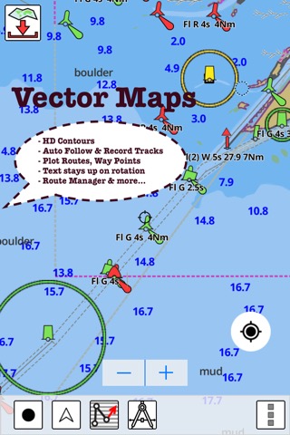
√ Beautiful and detailed Hardware/GPU accelerated vector charts (text stays upright on rotation)
√ Query details of Marine object (Buoy, Lights, Obstruction etc).
√ Customizable depth(Ft/Fathom/Meter) and distance units (km/mi/NM)
√ Customizable Shallow Depth.
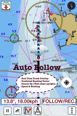
√ Record tracks, Autofollow with real-time track overlay & predicted path vector.
√ Voice Prompts for marine navigation (requires GPS )
√ 1ft / 3ft depth contour maps for anglers for selected lake maps.
√ Supports GPX/KML for boating route editing/import.
√ Tide & Currents prediction.
√ Seamless chart quilting. Map details from Coastal, Approaches,Harbour, Inland Encs(rivers), and general ENC charts are automatically mapped to correct zoomlevel
√ Enter or import Waypoints.
► MAPS
Get all the details that you find in your chart plotters!
(More regions are added every week) Please check website. Includes unlimited updates for 1 year.
Europe Inland Rivers & Waterways: Donau/Danube/Dunaja,Rhine,Rhein,Garonne,Moselle,Drava,Sava,etc.
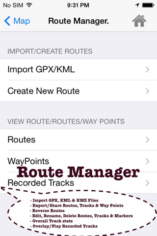
►ROUTE MANAGEMENT / TRIP PLANNING
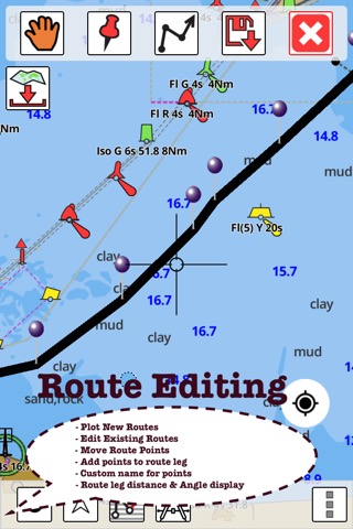
√ Create New Route/Edit Routes
√ Reverse Routes
√ Enter,Move, Add, Delete, Rename Waypoints
√ Import GPX, KML & KMZ files
√ Plot/Edit Routes
√ Share/Export Routes, Tracks & Markers
►GPS FEATURES
√ Auto Follow
* Real Time Track Overlay
* Predicted Path Vector
* Course Up (Text stays upright)
* Speed & Heading
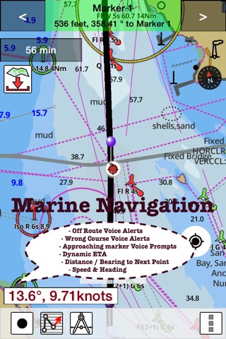
√ Route Assistance With Voice Prompts
* Prompts when approaching a boating route marker
* Continous distance & ETA updates
* Alerts when sailing/boating off route
* Alerts when boating in wrong direction
√ Record Tracks
►TIDE & CURRENTS
* For US, Canada, UK,Germany&New Zealand
* High/Low Tides
* Tidal Current Prediction
* Active Current Stations
► SHARING
* Share tracks/routes/markers on Facebook & Twitter
* Export tracks/routes/markers as compressed GPX files.
*Austria - Donau
*Belgium - Rupel, Netekanaal, Ringvaart om Gent, Schelde-Rijnverbinding, Dijle, Kanaal naar Charleroi, Beneden Zeeschelde, Bocholt-Herentals, Gent-Terneuzen, van Zeebrugge Achterhaven-inclusief het Boudewijnkanaal-tot en met haven Brugge, Zuid-Willemsvaart, Antwerpen Haven, Moervaart, Beneden-Nete, Dessel-Kwaadmechelen, Estuaire Vaart van Zeebrugge tot aan de Nederlandse Grens, Leie, Oostende Plassendalekanaal, Boven-Schelde, Vlaanderen, Zeekanaal, Albertkanaal, Oostende Haven met de 5-mijlszone Estuaire Vaart, Zeeschelde,
*Bulgaria
*Switzerland - Rhine
*Czech Republic - Roudnice nad Labem, Kly, Lovosice, Libotenice, Kostelec nad Labem, Melnik, Hraz Slapske prehrady, Praha - Holesovice, Steti, Libcice nad Vltavou, Praha - Modrany, Podebrady, Usti nad Labem, Veltruby, Melnik - soutok, Vrane nad Vltavou, Chvaletice, Vranany, Hradistko, Dolni Zleb, Neratovice, Celakovice, Statni hranice CR - SRN, Nymburk, Brna nad Labem, Brandys nad Labem, Kralupy nad Vltavou, Litomerice, Hradistko, Male Brezno, Roztoky, Kolin, Decin,
*Germany - Elbe, Westoder, Ruhr, Rhein-Herne-Kanal, Untere Havel-Wasserstraße (Spandau - Plaue), Weser, Neckar, Berlin-Spandauer-Schifffahrtskanal, Donau, Rhein, Spree-Oder-Wasserstraße, Havel-Oder-Wasserstraße, Main-Donau-Kanal, Wesel-Datteln-Kanal, Elbe-Havel-Kanal, Dortmund-Ems-Kanal, Elbe-Seitenkanal, Mittellandkanal, Mosel, Main, Saar
*France - GRANDE SAONE, MOSELLE CANALISEE, LIAISON DUNKERQUE ESCAUT, GARONNE
*Croatia - DRAVA, DANUBE, SAVA
*Hungary - Danube
*Netherlands
*Romania - Maritime Danube, Sulina Channel, Danube Black Sea Channel
*Serbia - Danube, Sava, Tisa
*Slovakia - Dunaja / Danube
Please Note: "Continued use of GPS running in the background
can dramatically decrease battery life."