アプリオンは、世界のアプリランキングや口コミから、おすすめアプリをまとめている人気アプリ探しサイトです。

Fishing Points - Lake Maps [iPad]

Fishing Points - Lake Mapsのおすすめ画像1
Fishing Points - Lake Mapsのおすすめ画像2
Fishing Points - Lake Mapsのおすすめ画像3
Fishing Points - Lake Mapsのおすすめ画像4
Fishing Points - Lake Mapsのおすすめ画像5
Fishing Points - Lake Mapsのおすすめ画像6
Fishing Points - Lake Mapsのおすすめ画像7
Fishing Points - Lake Mapsのおすすめ画像8
Fishing Points - Lake Mapsのおすすめ画像9
Fishing Points - Lake Mapsのおすすめ画像10
<
>

Bist LLCのスポーツアプリ

「Fishing Points」は、Bist LLCが配信するスポーツアプリです。

スポーツ ナビゲーション

このアプリの話題とニュース

  • 大人の男性スマホユーザーに人気が出てきています。


  • 新バージョン136.0.0が配信開始。新機能や改善アップデートがされています。(6/28)


  • 2017年3月7日(火)にiPhoneとiPad両対応のユニバーサルアプリとしてリリース!


最新更新情報

version136.0.0が、2023年6月28日(水)にリリース

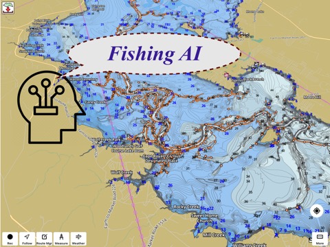
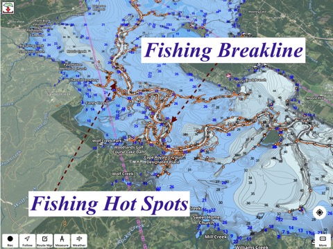
- Fishing AI improvements: More details at https://www.gpsnauticalcharts.com/main/fishing-hot-spots-ai
- Compiled with latest version of Xcode

使い方や遊び方

Only app with Fishing AI to find productive fishing breaklines and fishing spots.  It offers access to Fishing Lake Depth Maps & Marine Charts with fishing points for USA, Canada, UK, etc.  Coverage includes NOAA marine vector charts,freshwater lake maps,USACE inland river maps (HD/1ft bathymetry/Sonar Contours).


First Fishing GPS app to have route assistance with Voice Prompts for marine navigation. You can create new boating routes or import existing GPX/KML routes. It supports Nautical Charts course up orientation. Includes Tide & Currents prediction.


► FISHING AI
Emulates an expert angler. It is trained to include multiple variables.
√ Lake bathymetry/topography
* Point Bars
* Humps / Underwater Islands
* Channels
* Saddles
* Artificial / Man Made Structures
* River Bed
* Ledges
* Side Feeder Streams
* Pits
* And more...
√ Local Knowledge for a lake gained over the years about likely hot spots
√ Weather Patterns
√ Vegetation Maps
√ Fish Type


►FEATURES
√ Beautiful & detailed Hardware/GPU accelerated vector charts (text stays upright on rotation)
√ Long press to query the details of Marine object (Buoy,Lights,Obstruction etc).
√ Customizable depth(Ft/Fathom/Meter) & distance units(km/mi/NM)
√ Customizable Shallow Depth.
√ Record tracks,Autofollow with real-time track overlay & predicted path vector.
√ Voice Prompts for marine navigation (requires GPS )
√ 1ft / 3ft depth contour maps for anglers for selected lake maps.
√ Supports GPX/KML for boating route editing/import.
√ Tide & Currents prediction.
√ Seamless chart quilting of marine charts
√ Enter or import Waypoints.


► MAPS
It includes unlimited updates for 1 year.
√ Lake Maps & Nautical Charts with Fishing Points covering US, UK,Germany, NL, AU etc.


►ROUTE MANAGEMENT / TRIP PLANNING
√ Create New Route/Edit Existing Routes
√ Move Points
√ Add points to an existing route leg
√ Delete / Rename points
√ Import GPX,KML & KMZ files
√ Plot/Edit Routes
√ Enter Waypoints
√ Share/Export Routes,Tracks&Markers
√ Reverse Routes


►GPS FEATURES
√ Auto Follow
* Real Time Track Overlay
* Predicted Path Vector
* Course Up(Text stays upright)
* Speed & Heading
√ Route Assistance With Voice Prompts
* Prompts when approaching a boating route marker
* Continous distance & ETA updates
* Alerts when sailing/boating off route
* Alerts when boating in wrong direction
√ Record Tracks


►TIDE & CURRENTS
* For US, Canada, UK, Germany & New Zealand
* High/Low Tides
* Tidal Current Prediction
* Active Current Stations


► SHARING
* Share tracks/routes/markers on Facebook & Twitter
* Export tracks/routes/markers as compressed GPX files.


Sample Charts
√ KISSIMMEE, Lake Apopka, ISTOKPOGA, SEMINOLE, TOHOPEKALIGA, Lake Tohopekaliga, HARRIS, Lakeocklawaha,
√ East Lake Tohopekaliga, Bighenderson, GRIFFIN, MONROE, TALQUIN, Lake Eustis, EUSTIS, WEOHYAKAPKA,
√ ORANGE , HARNEY, MICCOSUKEE, HATCHINEHA, SANTA FE SWAMP, Farm 13 Stick Marsh, Weir,
√ LOCHLOOSA , Crooked Lake, MARIAN, DEER POINT , HANCOCK, ROSALIE,
√ DORA, POINSETT, CROOKED , SANTA FE , RIVER STYX, Lake Yale,
√ YALE, CYPRESS , Lake Louisa, KERR, ARBUCKLE, PIERCE, June, JACKSON, PANASOFFKEE,
√ ALLIGATOR , DOCTORS , REEDY , OKAHUMPKA SWAMP, Jackson, Forest North, ROUSSEAU, MARION,
√ WASHINGTON, JOHNS , TARPON, Lake Minnehaha, HAMILTON, WOODRUFF, TIGER ,
√ DEXTER, PARKER, SAMPSON, COBB MARSH, Lake Minneola, GENTRY, DORR, BUTLER, Kingsley,
√ WINDER, TRAFFORD, BUFFUM, Josephine, TIBET, CLINCH, OKAHUMPKA,
√ LITTLE SANTA FE , ELOISE, Cherry Lake, BEAUCLAIR, MATTIE, CONWAY, SOUTH ,
√ OTTER SLOUGH, Bigsand, ASHBY, ARIANA, Hampton, CYPRESS CREEK, JULIANA, ,


PLEASE NOTE: Continued use of GPS running in the background can dramatically decrease battery life.

カスタマーレビュー・評価

2.0
5つ星
 
0
4つ星
 
0
3つ星
 
0
2つ星
 
1
1つ星
 
0

最新ストアランキングと月間ランキング推移

Fishing PointsのiPadアプリランキングや、利用者のリアルな声や国内や海外のSNSやインターネットでの人気状況を分析しています。

基本情報

仕様・スペック

対応OS
8.0 以降
容量
52.0 M
推奨年齢
全年齢
アプリ内課金
あり
更新日
2023/06/28

リリース日
2017/03/07

集客動向・アクティブユーザー分析

オーガニック流入


アクティブ率


※この結果はFishing Points - Lake Mapsのユーザー解析データに基づいています。

アプリ内課金の売れ筋ランキング

  • 1位: Lithuania - Marine Charts (3000円)

  • 2位: Poland - Marine Charts (3000円)

  • 3位: Iceland - Marine Charts (5000円)

  • 4位: Scotia Sea- Marine Charts (3000円)

  • 5位: Maldives & Sri Lanka (3500円)

  • 6位: Fiji / Vanuatu Islands (3500円)

  • 7位: South China Sea & Malaysia (3500円)

  • 8位: Argentina - Marine Charts (4500円)

  • 9位: Malta,Cyprus Mediterranean (5000円)

  • 10位: Faroe Islands - Marine Charts (5000円)

利用者の属性・世代

アプリ解析デモグラフィックデータ(男女年代比率66%)

んんん~~どうでしょ~~~~

デモグラフィックデータを元にユーザー層の性別や年齢分布などを考慮して推定しています。

ネット話題指数

開発会社の配信タイトル

このアプリと同一カテゴリのランキング

吉野家 牛丼 (20食) [牛丼の具]
吉野家
amazon

Bist LLC のアプリ

Bist LLC の配信アプリ >

新着おすすめアプリ

新着おすすめアプリ >

注目まとめ

iPadアプリまとめ >