アプリオンは、世界のアプリランキングや口コミから、おすすめアプリをまとめている人気アプリ探しサイトです。

Orienteering Companion [iPhone]

Kristian Holmlundが配信するiPhoneアプリ「Orienteering Companion」の評価や口コミやランキング推移情報です。このアプリには「ナビゲーション」などのジャンルで分類しています。APPLIONでは「Orienteering Companion」の他にもあなたにおすすめのアプリのレビューやみんなの評価や世界ランキングなどから探すことができます。

現在、このアプリは非公開になっている可能性があります (探す)
Orienteering Companionのおすすめ画像1
Orienteering Companionのおすすめ画像2
Orienteering Companionのおすすめ画像3
<
>

Kristian Holmlundの地図/ナビアプリ

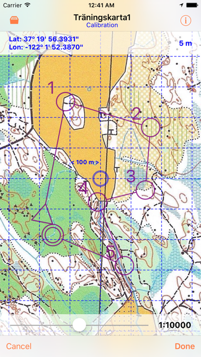
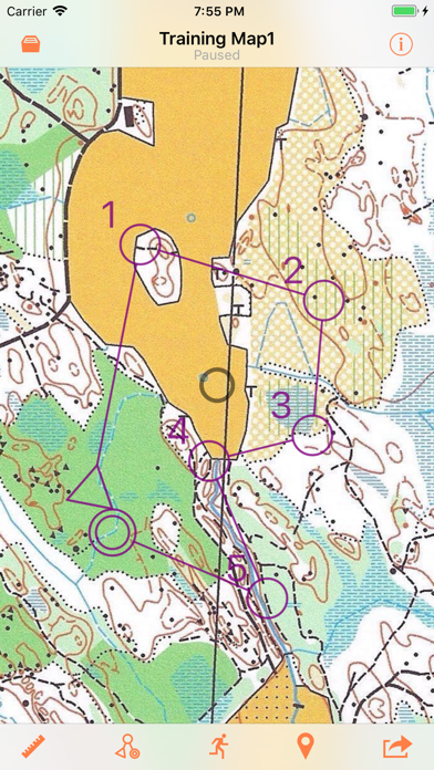
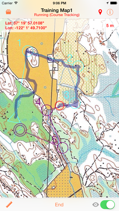
「Orienteering Companion」は、Kristian Holmlundが配信する地図/ナビアプリです。

ナビゲーション

このアプリの話題とニュース

  • 新バージョン3.6.2が配信開始。新機能や改善アップデートがされています。


  • 2013年3月26日(火)にiPhone版がリリース!


最新更新情報

version3.6.2が、2018年9月12日(水)にリリース

Fixed some bugs that prevented importing .KMZ files that are exported from OCAD with the option "KMZ Google Earth (Raster)".

使い方や遊び方

Orienteering Companion is an outdoor map utility for iPhone, which is primarily intended for orienteering training. The position of the user is displayed in real time on a map image that has been imported from the picture library and calibrated by the user.

The app uses the Location Services in the device to get the current position information. The accuracy is at best +/- 5 meters, which requires a good GPS reception.

Map images that have been imported are saved in a map collection. A new map image must be calibrated the first time before it can be used. After that, a calibrated map can be used unlimited number of times without any need for recalibration.


Features:
- Map Sharing:
The maps can be shared with other users of the app.
- Map Import:
Maps in the form of KML/KMZ files (Google Earth map format) that contain calibrated map image overlays can be imported from websites and are ready for use in the app.
- Snapshot of Maps:
The currently used map, with visible track details can be captured to the Picture library.
- Logged Tracks:
The user can choose to log the run and see the actual track in real-time. Logged tracks can be exported in GPX format to be used with other applications.
- Courses:
Orienteering waypoint symbols (virtual flags) can be created using a built-in editor for each map. The user can practice run against the course that has been created in order to "find" the waypoint flags and get a result with found flags, split times and distance information. The course run is logged and the result can be viewed later and exported just like any logged track.


Note:
- Your use of this real time route guidance application is at your sole risk. Location data may not be accurate.
- Continued use of GPS running in the background can dramatically decrease the battery life.
- Maps are normally protected by copyright and the user must make sure to own the right to copy the images of the maps that are to be imported to the app.

最新ストアランキングと月間ランキング推移

Orienteering CompanionのiPhoneアプリランキングや、利用者のリアルな声や国内や海外のSNSやインターネットでの人気状況を分析しています。

基本情報

仕様・スペック

対応OS
9.0 以降
容量
4.6 M
推奨年齢
全年齢
アプリ内課金
なし
更新日
2018/09/12

リリース日
2013/03/26

集客動向・アクティブユーザー分析

オーガニック流入

アクティブ率

※この結果はOrienteering Companionのユーザー解析データに基づいています。

ネット話題指数

開発会社の配信タイトル

このアプリと同一カテゴリのランキング

パワフルプロ野球2024-2025 (Switch)
コナミデジタルエンタテインメント
amazon

新着おすすめアプリ

新着おすすめアプリ >

注目まとめ

iPhoneアプリまとめ >

ダウンロード数が多いおすすめアプリ

無料ゲームアプリランキング >