アプリオンは、世界のアプリランキングや口コミから、おすすめアプリをまとめている人気アプリ探しサイトです。

HiiKER: The Hiking Maps App [iPhone]

Waymarked Trails LTDが配信するiPhoneアプリ「HiiKER: The Hiking Maps App」の評価や口コミやランキング推移情報です。このアプリには「ナビゲーション」「ヘルスケア/フィットネス」などのジャンルで分類しています。APPLIONでは「HiiKER: The Hiking Maps App」の他にもあなたにおすすめのアプリのレビューやみんなの評価や世界ランキングなどから探すことができます。

現在、このアプリは非公開になっている可能性があります (探す)
HiiKER: The Hiking Maps Appのおすすめ画像1
HiiKER: The Hiking Maps Appのおすすめ画像2
HiiKER: The Hiking Maps Appのおすすめ画像3
HiiKER: The Hiking Maps Appのおすすめ画像4
HiiKER: The Hiking Maps Appのおすすめ画像5
HiiKER: The Hiking Maps Appのおすすめ画像6
HiiKER: The Hiking Maps Appのおすすめ画像7
HiiKER: The Hiking Maps Appのおすすめ画像8
<
>

Waymarked Trails LTDの地図/ナビアプリ

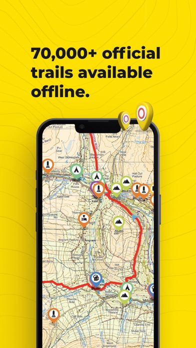
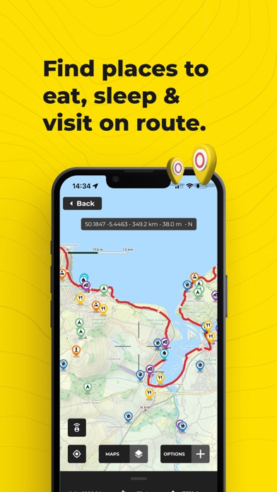
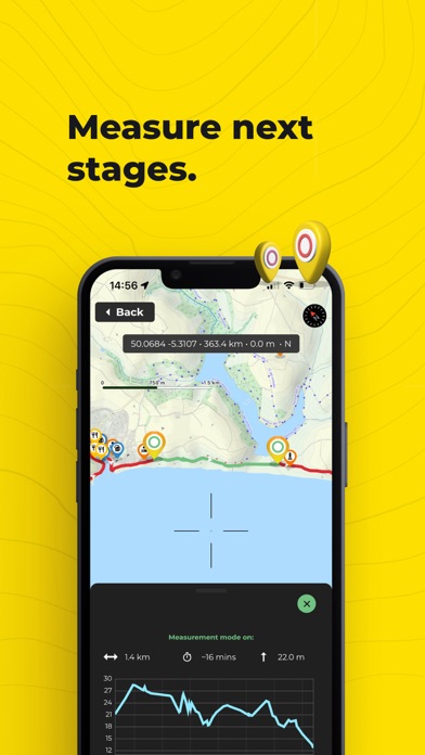
「HiiKER: The Hiking Maps App」は、Waymarked Trails LTDが配信する地図/ナビアプリです。

ナビゲーション ヘルスケア/フィットネス

このアプリの話題とニュース

  • 新バージョン4.009が配信開始。新機能や改善アップデートがされています。(1/9)


  • 2019年7月26日(金)にiPhoneとiPad両対応のユニバーサルアプリとしてリリース!


最新更新情報

version4.009が、2024年1月9日(火)にリリース

New Feature! Add a waypoint when you "Go to location". Add a grid reference/Lat-lon, then navigate to that point! Minor bug fixes.

使い方や遊び方

HiiKER is the hiking app that is dedicated to building tools specifically for the hiking community. More than just a map and a compass, the app enables you to hike in the great outdoors with confidence, now with free offline maps.


Discover thousands of Hiking trails
With HiiKER, you can discover one of over 70,000 of the world’s best hiking, thruhiking, walking and backpacking trails right from your smartphone. Looking for the perfect Family hike? Or want to take the dog out on a walk in nature?
Maybe you’re planning a multi-day hiking adventure. Or you're looking for one of those spectacular Lake District Hikes you’ve heard about. You’ll find the trail that’s right for you with our powerful search tool. All trails are available to download offline while in the mountains.


Plan Ahead
You’ll find thousands of accommodation and amenity options for your adventures. Plan ahead with the perfect lunch spot, campsite, resupply town or maybe even a 5-star hotel on your hiking trip.


Create your own custom trail
The HiiKER Trail Planner will enable you to blaze your own trail and plan a custom hike. You can share all trails with your adventure crew so that everyone is prepared for the hike.


Import GPX files
Got a GPX file of an awesome hiking trail from a friend or other source? Import it to HiiKER and make your own edits to the route before hitting the trail.


Track your Hikes
The HiiKER GPS Tracker records your hiking activity and gives you in-depth detail about your walks that you can share with your adventure crew. Got an ultra run you want to record? HiiKER has you covered. Forgot your compass? Let HiiKER be your compass and get your bearings with our intelligent maps.


High-Resolution Map layers
We are building the most comprehensive selection of free map layers available. You'll find the layer that is best suited to your hike. These maps include
Thunderforest
Open street maps
Satellite
Nature
IGN France
USGS
Get Lost


Offline Maps
With HiiKER PRO you can download all your favourite hiking trails to your phone to use offline - even in airplane mode. This is perfect for those hiking adventures where cell service is not guaranteed. It is also much less intensive on your battery life, meaning you can use it for longer!
Heading out on the End to End Trail? Or the West Highland Way? Maybe you’re bagging Munros or Wainwrights. Save the map to your device to make sure you’ll always have it when you need it.


Measure the Distance
While exploring the map, use our handy measurement tool to know what distance, terrain and elevation lie ahead on your hiking trail. This gets you ready for any change in elevation gain/loss and allows you to know how much time the section of the hiking trail will take.


GPX Download
Export GPX files of one of the thousands of hiking trails on HiiKER. Sync them with your other gps devices, such as Garmin Smartwatches, Garmin navigation devices, Coros watches, Suunto watches and many other navigation devices that support GPX, KML and GEOJSON files.


Print trail maps
Get that compass out and always make sure you have a backup by printing our high-resolution PDF trail maps


Premium High-Resolution maps
With HiiKER PRO+, you get access to some of the world's best map makers in the world on the platform. These high-resolution maps include
OS Maps
Harvey Maps
Ordnance Survey Ireland
EastWest Mapping
USGS
TASMAP
Get lost
Vicmap
LINZ


All of these maps can be used in conjunction with other HiiKER features.


Quality Data
We partner with trail organisations, such as the Bibulmunn Track, The Te Araroa, The Larapinta trail, The Pacific Crest Trail, The South west Coast Path and National parks and other trusted sources around the world to bring you the most up-to-date and official trail data available.


Contact us at support-central@hiiker.co


Legal
Terms of Service: https://hiiker.app/terms-of-service

カスタマーレビュー・評価

4.3
5つ星
 
2
4つ星
 
0
3つ星
 
1
2つ星
 
0
1つ星
 
0

最新ストアランキングと月間ランキング推移

HiiKER: The Hiking Maps AppのiPhoneアプリランキングや、利用者のリアルな声や国内や海外のSNSやインターネットでの人気状況を分析しています。

基本情報

仕様・スペック

対応OS
15.0 以降
容量
103 M
推奨年齢
全年齢
アプリ内課金
あり
更新日
2024/01/09

リリース日
2019/07/26

集客動向・アクティブユーザー分析

オーガニック流入

アクティブ率

※この結果はHiiKER: The Hiking Maps Appのユーザー解析データに基づいています。

アプリ内課金の売れ筋ランキング

  • 1位: HiiKER PRO + - Monthly (800円)

  • 2位: HiiKER PRO + - Annual (7000円)

  • 3位: HiiKER PRO + - Annual - 75% (7000円)

  • 4位: HiiKER PRO + - Annual - 50% (7000円)

  • 5位: HiiKER PRO 3 Year Sale (6000円)

  • 6位: HiiKER PRO+ 3 Year Sale (18000円)

  • 7位: HiiKER PRO + - 3 Year - Sale (15000円)

  • 8位: HiiKER PRO - 3 Year - Sale (6000円)

  • 9位: HiiKER PRO+ Annual Sale offer (6000円)

  • 10位: HiiKER PRO Annual Discount (2700円)

ネット話題指数

開発会社の配信タイトル

このアプリと同一カテゴリのランキング

スパイファミリー オペレーション ダイアリー (Switch)
BANDAI NAMCO Entertainment
amazon

Waymarked Trails LTD のアプリ

Waymarked Trails LTD の配信アプリ >

新着おすすめアプリ

新着おすすめアプリ >

注目まとめ

iPhoneアプリまとめ >