アプリオンは、世界のアプリランキングや口コミから、おすすめアプリをまとめている人気アプリ探しサイトです。

Airmate [iPad]

  • 入賞・受賞歴 月間ナビゲーション部門最高ランキング 135位を獲得!(4/20)
Airmateのおすすめ画像1
Airmateのおすすめ画像2
Airmateのおすすめ画像3
Airmateのおすすめ画像4
Airmateのおすすめ画像5
Airmateのおすすめ画像6
<
>

Myriel Aviation SAの地図/ナビアプリ

「Airmate」は、Myriel Aviation SAが配信する地図/ナビアプリです。

ナビゲーション 天気

このアプリの話題とニュース

  • 新バージョン3.15が配信開始。新機能や改善アップデートがされています。(4/16)


  • 2016年9月3日(土)にiPhoneとiPad両対応のユニバーサルアプリとしてリリース!


このレビュアーのおすすめコメント

This app is very useful to make flight plans. On the other hand, this app says “pay donation or upgrade pro” after latest update. I’ll buy and upgrade the pro when I know what has better, but I
what is the difference between normal and pro? - ★★★★★

最新更新情報

version3.15が、2024年4月16日(火)にリリース

Update fixing a plate download failure for the first operation and including previous version improvements:
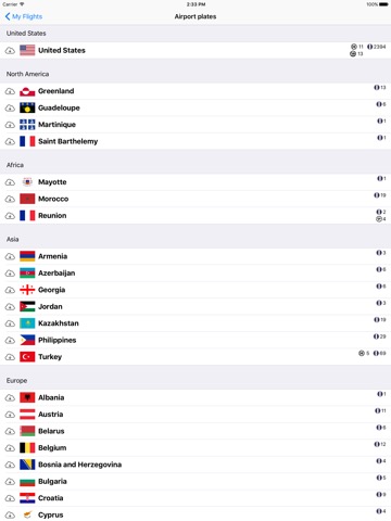
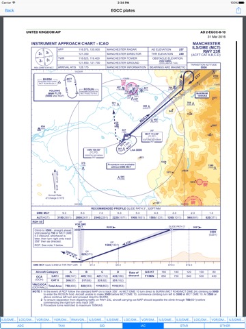
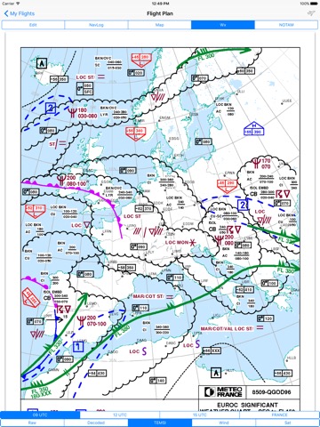
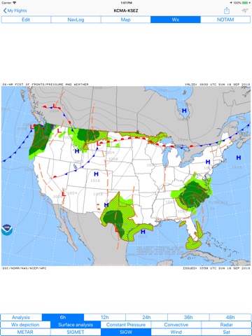
- Download of airport diagrams and approach plates for a whole country now done with a country package with additional integrity checks.
- Real time position sharing with other Airmate users may be enabled or disabled from the layers button (disabled by default for privacy)
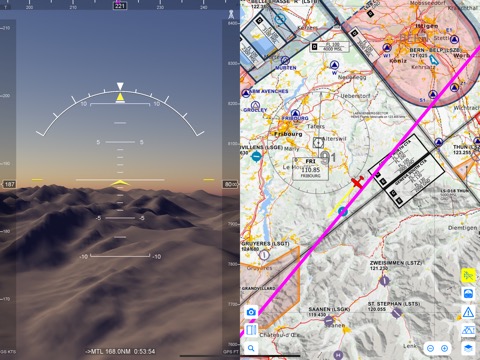
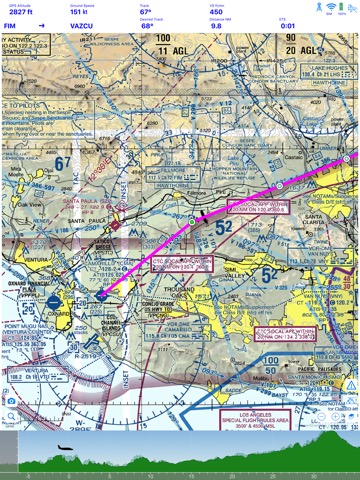
- Improved mapping controls, with the ability to switch anytime between map vector, raster and Satellite views
- Increased zooming capability on the Satellite view
- Improved display of nearby traffic received either over the mobile network (no equipment needed) or a supported ADS-B receiver or avionics.
- Improvement in the traffic warning window showing potential conflicting traffic (informational only, Airmate is not an approved collision avoidance device, and the pilot-in-command remains the only responsible for collision avoidance).
- Traffic received from mobile network or a connected hardware receiver may be forwarded to other apps (Airmate Premium required)
- Improved display for Flight Information Sectors (FIS)
- Fix a loading issue for some IFR approaches where legs may be loaded in duplicate.
- Fix an issue in the downloading of Airmate data for Dynon SkyView USB drive programming affecting subscribers in the USA region
- Thousands of Airmate airport diagrams now available in the USA for airfields without FAA diagrams (for information only).
- Fix display issues on iPhone 14 and 15 devices
- Fix an issue in the Airmate Pro option management that was sometimes incorrectly disabled, conversion of Airmate Pro to Airmate Premium.
- Miscellaneous other improvements.
- Fix various other issues and crashes.
- Include a worldwide aeronautical database at cycle 2404 (April 18th, 2024), automatically updated

使い方や遊び方

Airmate is a free and easy to use Electronic Flight Bag for pilots, providing help for flight planning and navigation, improving situational awareness and providing social sharing features.


Thanks to Airmate EFB flight planning tools, you will get instant access to airport data and aviation maps worldwide, up to date weather and NOTAMs, traffic around, and you could even file a flight plan.


IFR and VFR airport diagrams and plates are freely available in US (FAA charts), all Europe, and more than 200 other countries. Most of them are georeferenced and could be overlaid on the aviation chart. A powerful Plate Manager allows to download in advance all airport plates in a country, they could be easily printed and viewed.


During the flight, the moving map will display the aircraft location along the route, show airports and aeronautical data details, show traffic around and warn you if your planned route is crossing restricted areas. A profile view is available to display terrain elevation, crossed areas and forecasted weather across the route. Airmate can also display a backup aircraft attitude indicator and flight parameters in an EFIS-like view using the device internal sensors or a supported external AHRS-capable ADS-B receiver or supported aircraft avionics. In the whole world, Synthetic Vision displaying in the EFIS-like view the ups and downs of rolling terrain ahead is available.


Airmate includes a worldwide aeronautical database updated free of charge with airports, navigation beacons, waypoints, airways, obstacles, regulated and restricted areas. Topographic maps and elevation data for most countries may be downloaded free of charge, as well as additional aviation map overlays such US Sectionals. A procedure database provide details of departure (SID), arrival (STAR) and instrument approaches in specific countries, and you could add those procedures to your planned flight route (the procedure database includes all US airports, and many RNP approaches in other countries). Once loaded, the procedure path is displayed on the aeronautical map, including curved paths and racetracks.


When coupled with a supported external ADS-B received, Airmate will display nearby traffic on the moving map, and receive FIS-B weather and NOTAM during the flight. To improve safety, Airmate can display neighbouring traffic received over mobile network. Such traffic include commercial airlines and transponder-equiped aircrafts, FLARM gliders, aircrafts whose pilots are using Airmate and other users using other safety broadcasting equipment.


Airmate is able to transmit the flight plan data to and receive flight parameters and AHRS data from supported avionics such Dynon SkyView.


Thanks to the Auto Route feature, you could search and select the best route for your flight, and then file your flight plan anywhere in the world.


Airmate will also record your flights and allow to replay them later or export the flight path in gpx format. Pilot log entries are automatically computed from flown flights.


A Satellite map display mode in flight planning or replay mode allows to familiarize with significant landmarks.


Airmate will save planned and flown flights, user waypoints and user aircrafts in the cloud and sync them between your devices and Airmate web flight planning.


Airmate brings numerous social features to the community. Pilots may leave ratings, tips and comments to share their experience with fellow pilots, and report fuel prices and landing fees. They could find friends, instructors, flight schools, aviation events and aircraft to rent near their home airport or any visited airport.


Airmate may be connected to most flight simulators to keep flying skills sharp. Planned flights and personal waypoints may be imported and exported, including from/to flight simulators.


Continued use of GPS running in the background can dramatically decrease battery life.
Terms of Use: https://www.apple.com/legal/internet-services/itunes/dev/stdeula/

カスタマーレビュー・評価

4.7
5つ星
 
27
4つ星
 
4
3つ星
 
3
2つ星
 
0
1つ星
 
0

最新ストアランキングと月間ランキング推移

AirmateのiPadアプリランキングや、利用者のリアルな声や国内や海外のSNSやインターネットでの人気状況を分析しています。

基本情報

仕様・スペック

対応OS
12.0 以降
容量
202 M
推奨年齢
全年齢
アプリ内課金
あり
更新日
2024/04/16

リリース日
2016/09/03

集客動向・アクティブユーザー分析

オーガニック流入


アクティブ率


※この結果はAirmateのユーザー解析データに基づいています。

アプリ内課金の売れ筋ランキング

  • 1位: Airmate Pro version (3500円)

  • 2位: Support Airmate development! (700円)

  • 3位: Airmate Premium (3500円)

  • 4位: Turkey 2024 Rogers Data (12000円)

  • 5位: Tunisia VFR Air Million 2024 (3500円)

  • 6位: Slovenia VFR 2024 Rogers Data (7000円)

  • 7位: Sweden VFR Rogers Data 2024 (7000円)

  • 8位: Slovakia 2024 VFR Rogers Data (5000円)

  • 9位: Saudi Arabia 2024 Rogers Data (25000円)

  • 10位: Serbia 2024 Rogers Data (3500円)

利用者の属性・世代

アプリ解析デモグラフィックデータ(男女年代比率52%)

ゲッツ!!

デモグラフィックデータを元にユーザー層の性別や年齢分布などを考慮して推定しています。

ネット話題指数

開発会社の配信タイトル

このアプリと同一カテゴリのランキング

STREET FIGHTER 6 ファイティングスティックα (PS5,PS4,PC)
HORI
amazon

Myriel Aviation SA のアプリ

Myriel Aviation SA の配信アプリ >

新着おすすめアプリ

新着おすすめアプリ >

注目まとめ

iPadアプリまとめ >