アプリオンは、世界のアプリランキングや口コミから、おすすめアプリをまとめている人気アプリ探しサイトです。

Outside Maps [iPad]

Outside Mapsのおすすめ画像1
Outside Mapsのおすすめ画像2
Outside Mapsのおすすめ画像3
<
>

Replicade Ltd.の地図/ナビアプリ

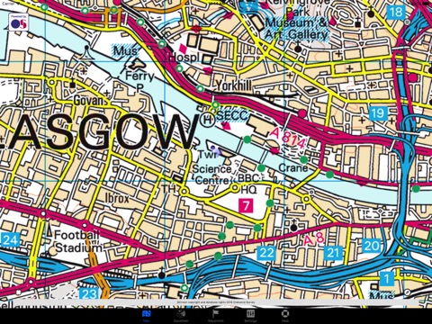
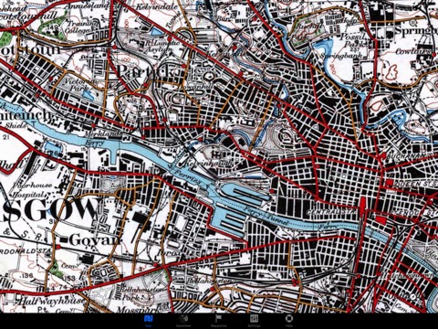
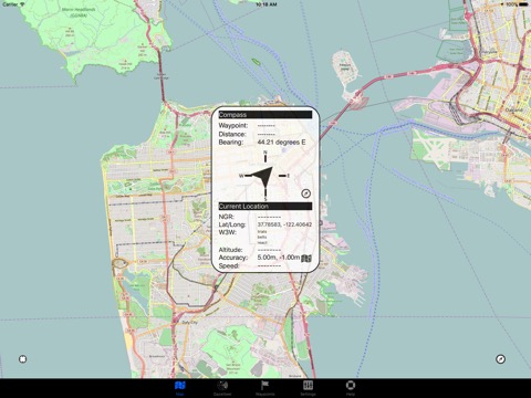
「Outside Maps」は、Replicade Ltd.が配信する地図/ナビアプリです。

ナビゲーション

このアプリの話題とニュース

  • 新バージョン3.7.2が配信開始。新機能や改善アップデートがされています。


  • 2011年2月26日(土)にiPhoneとiPad両対応のユニバーサルアプリとしてリリース!


最新更新情報

version3.7.2が、2022年2月5日(土)にリリース

- Added 1m Scotland Phase 1 LIDAR data

使い方や遊び方

*** Please do not use reviews to report bugs or ask for features. I almost never read the reviews and I cannot contact you for additional information! Contact support@outsidemaps.com instead ***


Outside Maps is an iPhone/iPad/iPod Touch application that enables you to view and navigate a wide variety of mapping data using an easy-to-use touch interface.


Outside Maps supports Ordnance Survey mapping for Great Britain at various scales including 1:50000.


Outside Maps supports WORLDWIDE coverage for OpenStreetMap, OpenCycleMap and the Stamen and Thunderforest map sources.


Outside Maps supports historic 1" Ordnance Survey mapping from 1880-1990 and 1921-1947 courtesy of the National Library of Scotland.


Outside Maps supports shaded terrain data for the UK only derived from Ordnance Survey OS Terrain 50. Outside Maps supports shaded terrain data for Scotland only derived from Scottish Government 1m LIDAR.


Outside Maps includes ESRI aerial photography courtesy of ESRI.


Outside Maps includes the following features:


- Intuitive "slippy maps" interface
- Native iPad support in both portrait and landscape modes
- Current Ordnance Survey mapping is available
- OpenStreetMap and derived data is supported at all available resolutions
- Historic 1" Ordnance Survey data from 1880-1990 and 1921-1947
- OpenCycleMap support
- Thunderforest "Landscape" and "Transport" mapping support
- Stamen mapping support
- ESRI aerial imagery
- Hill-shading mapping for the UK at 50m and selected 1m resolution
- Full Ordnance Survey OSTN02 adjustments for highest accuracy (+/- 1m accuracy)
- Real-time position tracking via GPS (or WiFi-based positioning)
- Compass and bearing (either using GPS and movement tracking or hardware compass if available)
- "Lookahead" feature when moving at > 5mph
- Waypoints functionality including import and export via GPX format
- OS OpenSpace-driven postcode and placename lookup (online only)
- Grid reference and latitude/longitude lookup (offline)
- what3words support (online only)

最新ストアランキングと月間ランキング推移

Outside MapsのiPadアプリランキングや、利用者のリアルな声や国内や海外のSNSやインターネットでの人気状況を分析しています。

基本情報

仕様・スペック

対応OS
12.0 以降
容量
10.0 M
推奨年齢
全年齢
アプリ内課金
なし
更新日
2022/02/05

リリース日
2011/02/26

集客動向・アクティブユーザー分析

オーガニック流入


アクティブ率


※この結果はOutside Mapsのユーザー解析データに基づいています。

利用者の属性・世代

アプリ解析デモグラフィックデータ(男女年代比率52%)

ゲッツ!!

デモグラフィックデータを元にユーザー層の性別や年齢分布などを考慮して推定しています。

ネット話題指数

開発会社の配信タイトル

このアプリと同一カテゴリのランキング

のっけるふりかけ 鮭明太
丸美屋
amazon

Replicade Ltd. のアプリ

Replicade Ltd. の配信アプリ >

新着おすすめアプリ

新着おすすめアプリ >

注目まとめ

iPadアプリまとめ >