アプリオンは、世界のアプリランキングや口コミから、おすすめアプリをまとめている人気アプリ探しサイトです。
アプリオンは、世界のアプリランキングや口コミから、おすすめアプリをまとめている人気アプリ探しサイトです。

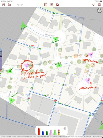
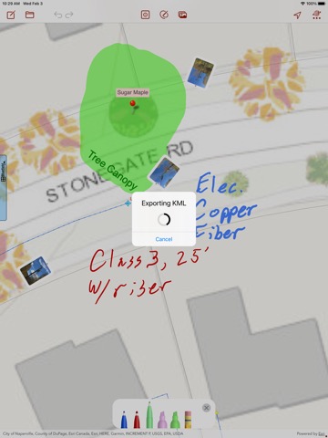
Draw Maps for ArcGIS
Bluefield GIS, Inc.
無料
iPhone / iPad対応
|
60 Trend |
このアプリの話題とニュース
新バージョン5.0.4が配信開始。新機能や改善アップデートがされています。
2019年2月8日(金)にiPhoneとiPad両対応のユニバーサルアプリとしてリリース!
最新更新情報
version5.0.4が、2021年4月23日(金)にリリース
Thank you for your feedback. New in this release:
- Broader connection and sync logging to help find communication problems in Collaboration maps.
Draw Maps for ArcGISのiPadアプリランキングや、利用者のリアルな声や国内や海外のSNSやインターネットでの人気状況を分析しています。
|
|
※この結果はDraw Maps for ArcGISのユーザー解析データに基づいています。
![]()
ファイナルアンサー!?
※デモグラフィックデータを元にユーザー層の性別や年齢分布などを考慮して推定しています。

¥700→¥50 : 死の淵に立たされた少女キレルとなり、復活するために死神の試練を7日以内に完遂させる、選択型ノベルアドベンチャーゲーム『7デイズ』が93%オフの大幅値下げ!
2024年05月22日 20:25

人々を魔剣に変えてしまう世界で、魔剣と化した少女エリスと共に、3形態に変化する力を駆使しながら世界を探索する、2DファンタジーRPG『RPG エルピシアの魔剣少女』がゲームアプリ内で話題に
2024年05月19日 19:00

【新作】多彩なブラシや自動保存機能など、初心者にも扱いやすいお絵描きアプリ『Pastela(パステラ)』のiPad版が配信開始!
2024年05月19日 18:00

【新作】サウナにお客さんを誘導し、のぼせる前に水風呂へ誘導し、冷える前に退出させて整えさせる、サウナ管理アクションゲーム『サウナでGO!』のiOS版が配信開始!
2024年05月22日 12:00

落ちていく砂を見ながら、残り時間の目安を視覚的にわからせてくれる、砂時計型キッチンタイマー『砂時計タイマー』がネットで取り上げられ話題に
2024年05月20日 08:00