アプリオンは、世界のアプリランキングや口コミから、おすすめアプリをまとめている人気アプリ探しサイトです。

Rome Metro & Tram by Zuti [iPhone]

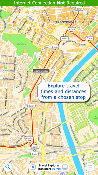
Visual IT Ltdが配信するiPhoneアプリ「Rome Metro & Tram by Zuti」の評価や口コミやランキング推移情報です。このアプリには「旅行」「ナビゲーション」などのジャンルで分類しています。APPLIONでは「Rome Metro & Tram by Zuti」の他にもあなたにおすすめのアプリのレビューやみんなの評価や世界ランキングなどから探すことができます。

Rome Metro & Tram by Zutiのおすすめ画像1
Rome Metro & Tram by Zutiのおすすめ画像2
Rome Metro & Tram by Zutiのおすすめ画像3
Rome Metro & Tram by Zutiのおすすめ画像4
Rome Metro & Tram by Zutiのおすすめ画像5
<
>

Visual IT Ltdのおでかけ情報アプリ

「Rome Metro & Tram by Zuti」は、Visual IT Ltdが配信するおでかけ情報アプリです。

旅行 ナビゲーション

このアプリの話題とニュース

  • 新バージョン5.2が配信開始。新機能や改善アップデートがされています。


  • 2013年6月20日(木)にiPhoneとiPad両対応のユニバーサルアプリとしてリリース!


最新更新情報

version5.2が、2018年4月4日(水)にリリース

This app has been updated by Apple to display the Apple Watch app icon.

1. User can now control the maximum amount of walking on any leg of a route.
2. Added ability to change the size of markers.

使い方や遊び方

● KEY FEATURES ●
● Simple, fast and easy to use guide and route planner for the metro, rail and trams in Rome.
● Clear colourful street map covers all of central Rome.
● Map and routing data are stored entirely on the device so no internet connection is required.
● A database of places of interest, parks, restaurants, shops etc, etc is included.
● Allows the user to easily mark up the map with points of interest or plot routes and mark areas of interest.
● Locates and tracks the user on the map using GPS.


● OVERVIEW ● The Rome Metro - Map and route planner from Zuti makes it easy to travel in and around Rome using the Metro, Tram and Urban rail networks. The application contains a detailed and colourful street map and route planner with many unique features. The map provides a clear view of the city transport services with the ability to show or hide the transport services and stops. The map and route planner are stored entirely on the device and are available anywhere and at any time, there is no need for an internet connection.


● TRAVEL EXPLORER ● The unique travel explorer feature provides a view of travel times using transport from any location on the map. This is helpful for getting a sense of scale and connectivity of the transport system and can provide some interesting results. For example is it quicker to use the metro and tram to travel from Colosseo to Venezia or is it quicker on foot? (Hint, the quickest route will keep you fitter). No other application makes it so easy to get around on the transport systems and allow you to make travel decisions based on the actual distances involved.


● ROUTING ● Does not require an internet connection and will always be available to display a clear and detailed view of the city transport system, plus list and display on the map the optimum route for your journey. Provides the fastest route calculations of any mobile routing application (virtually instantaneous) using actual published journey times with the ability to select the quickest route or the route with the least changes. Comprehensive details of your planned route are provided, including “direction”, “towards” and “service frequency” information (not available on any other offline journey planner) for example “Take the Metro B (Northbound) towards Rebibbia for 4 mins (2 stops). Service runs every 10 minutes” which is essential when finding the correct platform and direction. Also given are alternatives (if available) for each leg of the journey.


● ANNOTATING THE MAP ● You can now add places of interest, routes and areas to the map. This is a very simple yet powerful feature that allows the user to easily customise their map. This feature will also display the complete distance for a route. These annotations are stored on the device and can be shown or hidden as a group or individually.


● NO INTERNET CONNECTION REQUIRED ● The map and routing do not require an internet connection and you will not be charged data connection fees. This also means the application runs perfectly underground or on an aeroplane, etc. For international visitors to a city who have data roaming turned off this is an ideal solution.


● MORE MAPS ● This map is one in a series of Zuti worldwide city maps, if you like this product you may also enjoy some of our other offerings, please visit www.zuti.co.uk for further information.

最新ストアランキングと月間ランキング推移

Rome Metro & Tram by ZutiのiPhoneアプリランキングや、利用者のリアルな声や国内や海外のSNSやインターネットでの人気状況を分析しています。

基本情報

仕様・スペック

対応OS
8.0 以降
容量
127 M
推奨年齢
全年齢
アプリ内課金
なし
更新日
2018/04/04

リリース日
2013/06/20

集客動向・アクティブユーザー分析

オーガニック流入


アクティブ率


※この結果はRome Metro & Tram by Zutiのユーザー解析データに基づいています。

利用者の属性・世代

アプリ解析デモグラフィックデータ(男女年代比率52%)

犯人はこの中にいる!

デモグラフィックデータを元にユーザー層の性別や年齢分布などを考慮して推定しています。

ネット話題指数

開発会社の配信タイトル

このアプリと同一カテゴリのランキング

ドラゴンクエストXを支える技術
青山 公士
amazon

Visual IT Ltd のアプリ

Visual IT Ltd の配信アプリ >

新着おすすめアプリ

新着おすすめアプリ >

注目まとめ

iPhoneアプリまとめ >