Rivercast™ puts the river level data you need at your fingertips with its intuitive and interactive maps and graphs.
Rivercast™ Features Include:
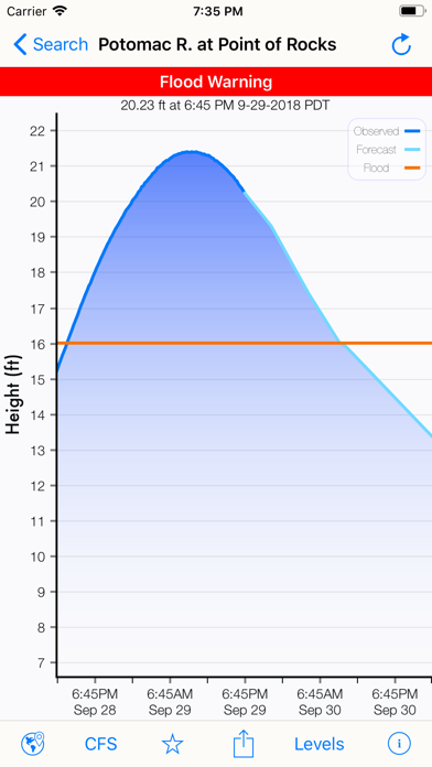
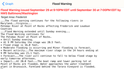
• Official Flood Warnings & other alerts from the National Weather Service
• River stage height in Feet
• River flow rate in CFS (when available)
• Indications that a river is at or approaching flood stage
• Current observations and recent history
• NOAA river forecasts (when available)
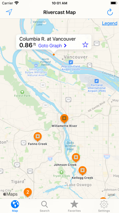
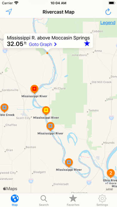
• Map interface that shows where river gauges are located geographically.
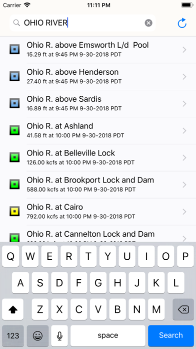
• Search interface to find river gauges by waterway name, state, or NOAA 5 digit station ID.
• Interactive graphs that you can zoom in, zoom out, or pan.
• Customize your graphs by adding river levels that are relevant to you.
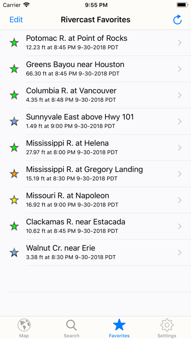
• Favorites list for locations you care about the most.
• Share your graphs via iMessage, Email, Facebook, or Twitter.
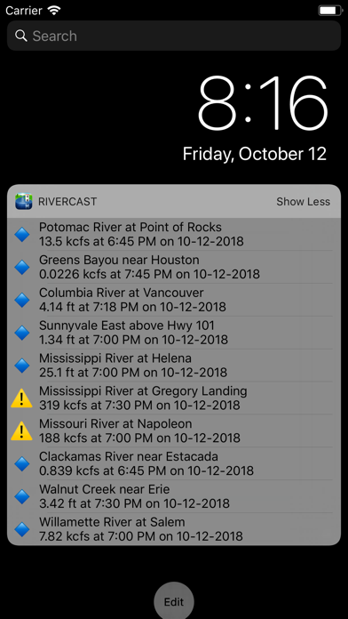
• Today Widget to monitor your favorite locations at any time.
Rivercast's map not only shows you where the stations are, but color codes them when it can to give you an indication whether the location is at normal levels, approaching flood levels, or above flood stage.
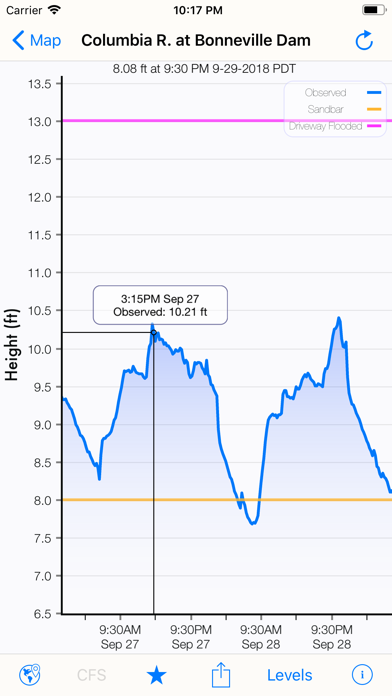
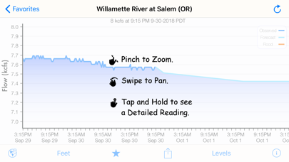
You can get the latest observations from the map, search, or favorites. With an additional tap of your finger you can get a detailed interactive hydrograph. You can zoom in, zoom out, or pan with your fingers to find the exact information you need. If you "tap and hold" on the graph you can view the crosshair "bubble" text to assist you further.
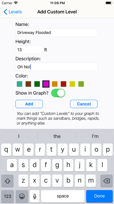
To customize your graphs for what's important to you, you can add your own level lines to mark things like sandbars, rocks, bridges, safe conditions, or whatever you would like.
And you can add the streams or rivers that you would like to regularly monitor to your Favorites list for easy "at a glance" viewing.
Rivercast™ uses the latest observation and forecast data available, and requires an Internet connection for use. We recommend 3G or better for optimal performance.
Favorites, Map "Instant Observations", and Hydrograph data is viewable in feet or cfs (when available).
All observation and forecast data is in your local time (per your device) for your convenience.
A handy tool for boaters, fishermen, property owners, paddlers, scientists, and the curious.
River gauges reported are USA only.
* * * * * * * * * * * * *
Some Frequent Asked Questions:
Where does Rivercast™ get its data?
• This app uses NOAA and AHPS (Advanced Hydrologic Prediction Service) for its raw data for our custom graphing and mapping solutions. There are a few locations that are available via other government agencies (including USGS) that are not available via this app.
Why does Rivercast™ sometimes show slightly different flow data (CFS) than USGS?
• CFS is a calculated estimate derived from stage height. NOAA and USGS estimates may sometimes slightly vary due to using different data models. Variances are usually within a few percent, but can sometimes be larger. Stage height should always be identical between USGS and NOAA. Designated flood stages are based on stage height in feet in the USA.
Why does Rivercast™ show only observations, but not forecasts, for my river?
• NOAA issues forecasts for many, but not all, rivers it monitors. Sometimes forecasts are only issued seasonally, or during times of flooding or high water.
My river gauge was there yesterday, but its gone today! What gives?
• River gauges have a hard life. They occasionally have technical problems transmitting their data, or can even get washed out during extreme flooding. NOAA is usually pretty good about fixing them in a few days.
Can you add location xyz to your app?
• We wish we could! If NOAA is not reporting it, we unfortunately are not able to add it. We include all stations that NOAA provides for public use.
We take our accuracy seriously!
If you have any questions (or complaints!), please email us.

![[パチスロ]政宗3](https://is1-ssl.mzstatic.com/image/thumb/Purple114/v4/94/ee/8a/94ee8a2d-2aff-687a-9846-d1a6c26d56c6/AppIcon_sim-1x_U007emarketing-0-5-0-85-220.png/100x100bb.jpg)