アプリオンは、世界のアプリランキングや口コミから、おすすめアプリをまとめている人気アプリ探しサイトです。
アプリオンは、世界のアプリランキングや口コミから、おすすめアプリをまとめている人気アプリ探しサイトです。
「The Colorado Trail Hiker」は、AtlasGuidesが配信する地図/旅行アプリです。

The Colorado Trail Hiker
AtlasGuides
無料
Android対応
旅行&地域
|
60 Trend |
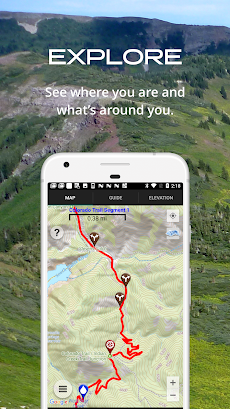
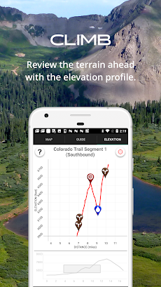

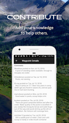
「The Colorado Trail Hiker」は、AtlasGuidesが配信する地図/旅行アプリです。
このアプリの話題とニュース
1万ダウンロード突破!
レビュースコア4.5をマークしている高評価の優良アプリです。(4/25)
100人を超える、評価・クチコミ投稿者数となっています。(4/25)
新バージョン7.3.2が配信開始。新機能や改善アップデートがされています。
最新更新情報
version7.3.2が、2021年9月22日(水)にリリース
6.0
--Improved performance/speed
--Improved location services
--Improved route creator tool
--Trail color option for colorblind/dark background
6.0.19
--fix photo download issue
--improve location awareness in guide and elevation profile
|
5つ星
106
4つ星
19
3つ星
1
2つ星
2
1つ星
1
|
The Colorado Trail HikerのAndroidアプリランキングや、利用者のリアルな声や国内や海外のSNSやインターネットでの人気状況を分析しています。
|
|
※この結果はThe Colorado Trail Hikerのユーザー解析データに基づいています。

ViewRanger
Augmentra
無料

GPS Status & Toolbox
MobiWIA Kft.
無料

GPS Status PRO - (legacy key)
MobiWIA Kft.
¥2,120

Great Divide Trail
AtlasGuides
無料

New England Hiker
AtlasGuides
無料

Guthook Guides Australia & New Zealand
AtlasGuides
無料

Trailblazer Walking Guides
AtlasGuides
無料

Wonderland Trail by Tami Asars
AtlasGuides
¥2,260

Runtastic Mountain Bike サイコン
Runtastic
無料

音声 GPS 運転 行き方 、 GPS ナビゲーション 、 地図
Delta raza apps
無料

¥3,000→¥1,500 : シナリオはFFの時田貴司、音楽はドラクエのすぎやまこういち!半熟な主人公達が、エッグモンスターを召喚して戦う、笑いとシリアスが融合した、名作リアルタイムシミュレーションRPG『半熟英雄(はんじゅくヒーロー)ああ、世界よ半熟なれ…!!』が半額セール!
2024年04月26日 05:05

¥2,400→¥1,200 : 語られることのなかったFF4のその後が描かれたRPG『ファイナルファンタジー4 THE AFTER YEARS 月の帰還』が半額セール!
2024年04月26日 00:25

【新作】機関銃や速射砲や対空ミサイルなど、対空兵器を使って空から襲ってくる戦闘機や外敵を破壊する、対空シューティングゲーム『スカイディフェンス』のAndroid版が配信開始!
2024年04月25日 12:00

【新作】バーチャルツアーで訪れた、猫のいる部屋から抜け出す、エスケープルームゲーム『CAT CAT HOUSE』のAndroid版が配信開始!
2024年04月26日 13:00

バーチャルインターネット空間のDJとなり、5種類のノーツにあわせ音楽と一体化する、より踏み込んだストーリーが展開する、美麗リズムタップゲーム『Cytus II (サイタスⅡ)』がゲームアプリ内で話題に
2024年04月26日 20:00
