アプリオンは、世界のアプリランキングや口コミから、おすすめアプリをまとめている人気アプリ探しサイトです。
アプリオンは、世界のアプリランキングや口コミから、おすすめアプリをまとめている人気アプリ探しサイトです。
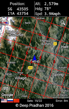
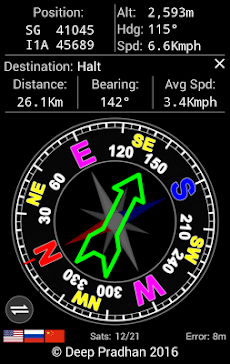
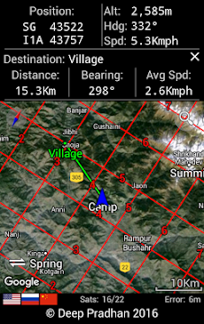
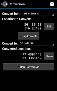
「Deesha: Indian Grid, GEOREF, MGRS, UTM/UPS」は、Deep Pradhanが配信するツールアプリです。

Deesha: Indian Grid, GEOREF, MGRS, UTM/UPS
Deep Pradhan
無料
Android対応
ツール
|
60 Trend |
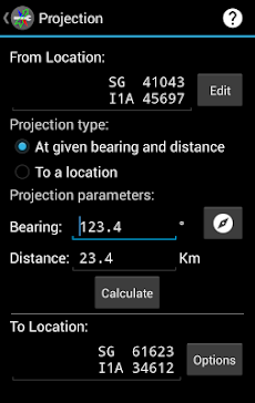
「Deesha: Indian Grid, GEOREF, MGRS, UTM/UPS」は、Deep Pradhanが配信するツールアプリです。
このアプリの話題とニュース
10万ダウンロード突破!
レビュースコア4.5をマークしている高評価の優良アプリです。(6/2)
800人を超える、評価・クチコミ投稿者数となっています。(6/2)
新バージョン2.4が配信開始。新機能や改善アップデートがされています。
最新更新情報
version2.4が、2017年11月22日(水)にリリース
• Fixed: Incorrect suggestion of Indian Grid Zone 1A instead of Zone 2A above 28°N.
• Fixed: Opening of files (CSV/GPX/JPEG/KML/KMZ) in Nougat and above.
• Fixed: Time selection in Sun Moon Information in Nougat and above.
• Updated: Links to website and method of joining Mailing list.
• Corrections and improvements.
• Multiple bug fixes.
|
5つ星
625
4つ星
131
3つ星
34
2つ星
13
1つ星
25
|
Deesha: Indian Grid, GEOREF, MGRS, UTM/UPSのAndroidアプリランキングや、利用者のリアルな声や国内や海外のSNSやインターネットでの人気状況を分析しています。
|
|
※この結果はDeesha: Indian Grid, GEOREF, MGRS, UTM/UPSのユーザー解析データに基づいています。

¥920→¥184 : クリスタルを守り、持ち運びながらダンジョンの各部屋を攻略して脱出を試みる、ディフェンスローグライクRPG『Dungeon of the Endless: Apogee』が80%オフの大幅値下げ!
2024年06月02日 00:10

素手から始まり武具を手に入れ、武器レベルなどをあげて強化していく、放置育成オートバトルRPG『ヴァンジ』が楽しめる無料ゲームとして注目される
2024年05月31日 17:00

3Dの立体マップにも対応した、世界中の航空写真を地球視点でグリグリ動かせる衛星地図アプリ『Google Earth』がネットで話題に
2024年06月01日 08:00

覚えきれてない単語を、自動で問題として表示してくれる、単語問題自動生成アプリ『モノグサ』がネットで話題に
2024年05月31日 14:00

高層にある殺風景なオフィスルームから抜け出す、会社脱出ゲーム『Office Space』へのアクセス利用数が伸びる
2024年06月01日 13:00

