アプリオンは、世界のアプリランキングや口コミから、おすすめアプリをまとめている人気アプリ探しサイトです。

LatLon Convertor [iPhone]

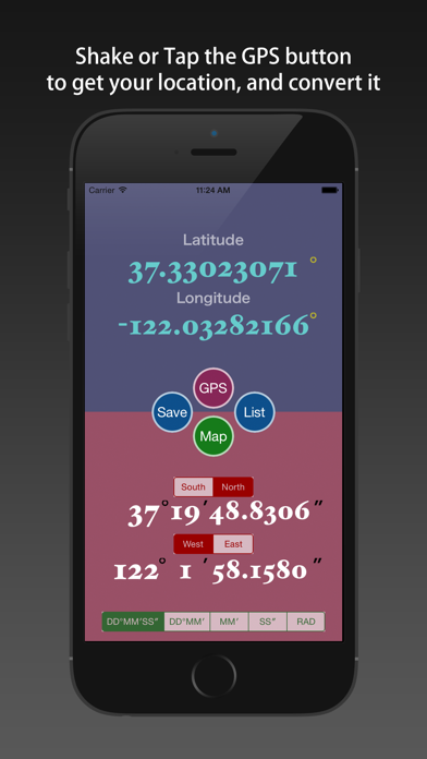
Jian Liが配信するiPhoneアプリ「LatLon Convertor」の評価や口コミやランキング推移情報です。このアプリには「ナビゲーション」「ユーティリティ」などのジャンルで分類しています。APPLIONでは「LatLon Convertor」の他にもあなたにおすすめのアプリのレビューやみんなの評価や世界ランキングなどから探すことができます。

現在、このアプリは非公開になっている可能性があります (探す)
LatLon Convertorのおすすめ画像1
LatLon Convertorのおすすめ画像2
LatLon Convertorのおすすめ画像3
LatLon Convertorのおすすめ画像4
LatLon Convertorのおすすめ画像5
<
>

Jian Liの地図/ナビアプリ

「LatLon Convertor」は、Jian Liが配信する地図/ナビアプリです。

ナビゲーション ユーティリティ

このアプリの話題とニュース

  • 女子高生や女子大生を中心に利用者層が増えてきています。


  • 新バージョン3.0が配信開始。新機能や改善アップデートがされています。


  • 2014年12月18日(木)にiPhoneとiPad両対応のユニバーサルアプリとしてリリース!


最新更新情報

version3.0が、2016年2月13日(土)にリリース

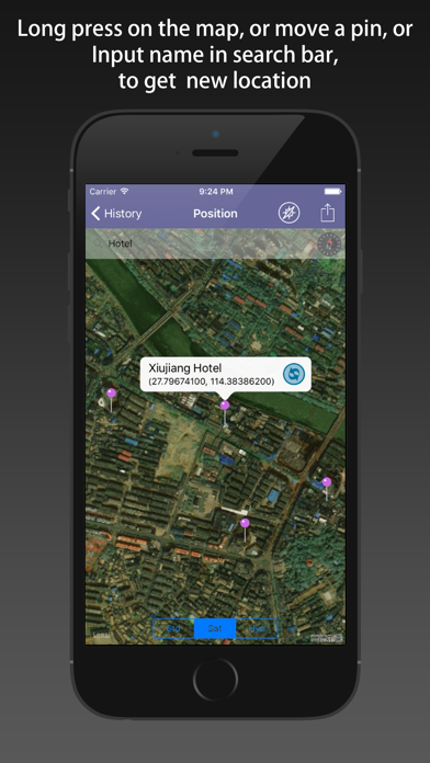
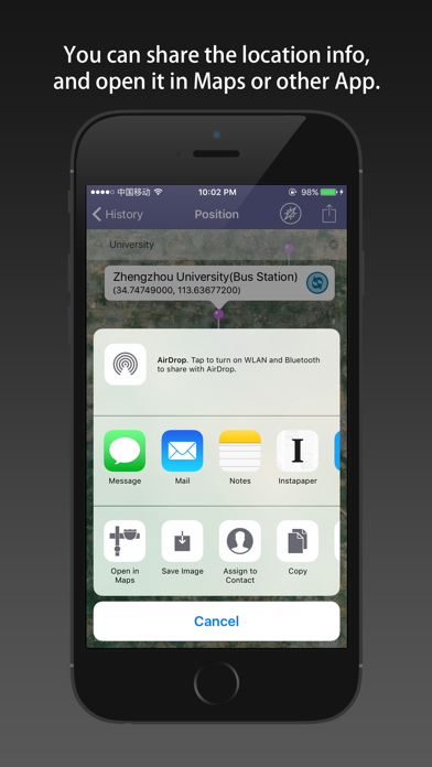
Added: a search bar on a page of the map, you can enter a location name to search, and call out the pins to transform it.
Added: In the map page, "open in Maps" button is added in "sharing" view (in the second row, you can edit the order), through which you can achieve in official Maps or other applications open the current position, thus realize the navigation.
Fixed: the position deviation in the China mainland area. Previous version has a bug, please update it. The updated software displays the coordinates of the numerical value is true coordinates.
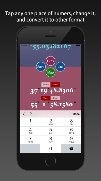
Changed: the UI map page, the "transform" and "Return" button and the location info label were removed. They are added to the Pin's call out view.
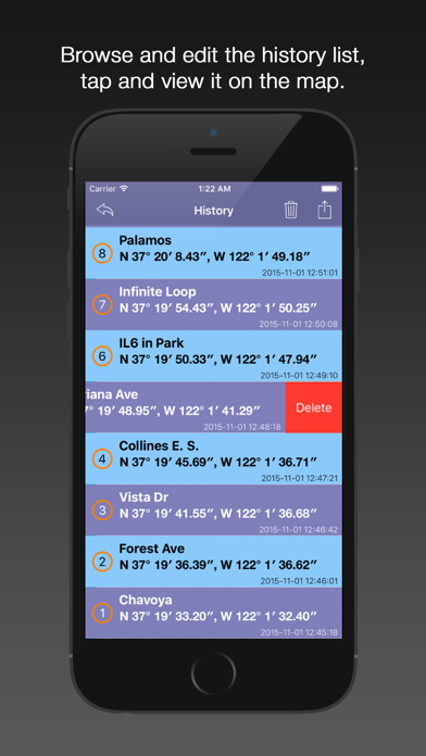
Added: the position name's default value, when you save the location.

使い方や遊び方

the App provides 6 types of the location input method, and 6 types of formats.


The "latitude" (Lat., φ, or phi) of a point on the Earth's surface is the angle between the equatorial plane and the straight line that passes through that point and is normal to the surface of a reference ellipsoid which approximates the shape of the Earth. This line passes a few kilometers away from the center of the Earth except at the poles and the equator where it passes through Earth's center. Lines joining points of the same latitude trace circles on the surface of the Earth called parallels, as they are parallel to the equator and to each other. The north pole is 90° N; the south pole is 90° S. The 0° parallel of latitude is designated the equator, the fundamental plane of all geographic coordinate systems. The equator divides the globe into Northern and Southern Hemispheres.


The "longitude" (Lon., λ, or lambda) of a point on the Earth's surface is the angle east or west from a reference meridian to another meridian that passes through that point. All meridians are halves of great ellipses (often improperly called great circles), which converge at the north and south poles. A line, which was intended to pass through the Royal Observatory, Greenwich (a suburb of London, UK), was chosen as the international zero-longitude reference line, the Prime Meridian. Places to the east are in the eastern hemisphere, and places to the west are in the western hemisphere. The antipodal meridian of Greenwich is both 180°W and 180°E. The zero/zero point is located in the Gulf of Guinea about 625 km south of Tema, Ghana.


There are many types of the express way for latitude and longitude, the App supports six kinds of common conversion between latitude and longitude format.
You can input a format of latitude and longitude, immediate access to the other five kinds of latitude and longitude. They are:
1) DDD.DDDDD° [degrees]
2) DDD°mm.mmm' [degrees - minutes]
3) DDD°mm' ss'' [degrees - minutes - seconds]
4) mm.mmm' [minutes]
5) ss.sss" [seconds]
6) radian

[Features]
1) support six common format conversion of latitude and longitude.
2) support using GPS to get the location, and transform.
3) support moving the pin on the map to obtain the latitude and longitude of the location, and transform them.
4) support saving the transformation results, and the history records can be viewed, deleted, cleaned up.
5) Every the historical record can be shown on the map, and each of them can be reduced again.
6) You can share one point to others by the Map Interface, and backup all of the history points list by email, the Txt file format, KML file format and PNG file format are both supported. You can open the KML file with Google Earth.

[Location Input Method]
1) shaking your iPhone/iPad.
2) using the keyboard input by hand.
3) using the GPS positioning.
4) moving the pin on the map.
5) long press on the map.
6) search position name on the map view.

最新ストアランキングと月間ランキング推移

LatLon ConvertorのiPhoneアプリランキングや、利用者のリアルな声や国内や海外のSNSやインターネットでの人気状況を分析しています。

基本情報

仕様・スペック

対応OS
7.0 以降
容量
12.5 M
推奨年齢
全年齢
アプリ内課金
なし
更新日
2016/02/13

リリース日
2014/12/18

集客動向・アクティブユーザー分析

オーガニック流入

アクティブ率

※この結果はLatLon Convertorのユーザー解析データに基づいています。

ネット話題指数

開発会社の配信タイトル

このアプリと同一カテゴリのランキング

オタク用語辞典 大限界
三省堂
amazon

Jian Li のアプリ

Jian Li の配信アプリ >

新着おすすめアプリ

新着おすすめアプリ >

注目まとめ

iPhoneアプリまとめ >