アプリオンは、世界のアプリランキングや口コミから、おすすめアプリをまとめている人気アプリ探しサイトです。

Singapore MRT Map Route(Pro) [iPhone]

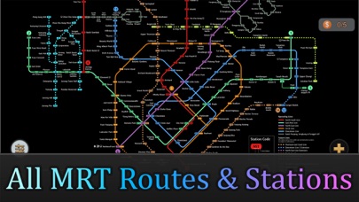
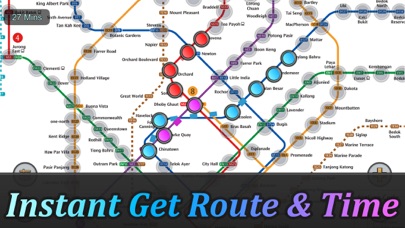
Wan Pengが配信するiPhoneアプリ「Singapore MRT Map Route(Pro)」の評価や口コミやランキング推移情報です。このアプリには「ナビゲーション」「旅行」などのジャンルで分類しています。APPLIONでは「Singapore MRT Map Route(Pro)」の他にもあなたにおすすめのアプリのレビューやみんなの評価や世界ランキングなどから探すことができます。

  • 入賞・受賞歴 月間ナビゲーション部門最高ランキング 183位を獲得!(4/18)
Singapore MRT Map Route(Pro)のおすすめ画像1
Singapore MRT Map Route(Pro)のおすすめ画像2
Singapore MRT Map Route(Pro)のおすすめ画像3
Singapore MRT Map Route(Pro)のおすすめ画像4
Singapore MRT Map Route(Pro)のおすすめ画像5
Singapore MRT Map Route(Pro)のおすすめ画像6
Singapore MRT Map Route(Pro)のおすすめ画像7
<
>

Wan Pengの地図/ナビアプリ

「Singapore MRT Map Route(Pro)」は、Wan Pengが配信する地図/ナビアプリです。

ナビゲーション 旅行

このアプリの話題とニュース

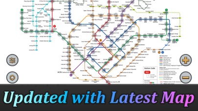
  • 新バージョン2.5.0が配信開始。新機能や改善アップデートがされています。(7/12)


  • 2011年11月4日(金)にiPhoneとiPad両対応のユニバーサルアプリとしてリリース!


最新更新情報

version2.5.0が、2023年7月12日(水)にリリース

Updated Thomson-East Coast Line (TE1 Woodlands North to Gardens by the Bay) to the subway system.

Optimized calculation speed to improve the overall performance of the application.

Fixed known issues and bugs to enhance the stability and reliability of the application.

使い方や遊び方

Updated Thomson-East Coast Line (TE1 Woodlands North to Gardens by the Bay) to the subway system.


Exclusive Dark Mode.


Singapore's MRT system is extending. By 2030, the MRT system will be more complex than you could image. It's good for all residents on our lovely island. But also will be a problem because we don't know how to travel the fastest when transfering stations.


Singapore MRT Map Route is designed to allows user to get the best route within a second. It will help you save a lot of time over years.


- View lastest Singapore MRT map
- Display the best route between two stations
- Automatically calculate estimated travel time
- Require no internet connection.


Updated to latest MRT system:


Downtown Line(Blue)
Bukit Panjang, Cashew, Hillview, Beauty World, King Albert Park, Sixth Avenue, Tan Kah Kee, Botanic Gardens, Stevens, Newton, Little India, Rochor, Bugis, Promenade, Bayfront, Downtown, Telok Ayer, Chinatown


Circle Line(Yellow)
Dhoby Ghaut, Bras Basah, Esplanade, Promenade, Nicoll Highway[C], Stadium, Mountbatten, Dakota, Paya Lebar, MacPherson, Tai Seng, Bartley, Serangoon, Lorong Chuan, Bishan, Marymount, Caldecott, Botanic Gardens, Farrer Road, Holland Village. Buona Vista, one-north, Kent Ridge, Haw Par Villa, Pasir Panjang, Labrador Park, Telok Blangah, HarbourFront


East West Line (Green)
Pasir Ris ,Tampines , Simei , Tanah Merah , Bedok , Kembangan , Eunos , Paya Lebar , Aljunied , Kallang , Lavender , Bugis , City Hall , Raffles Place , Tanjong Pagar , Outram Park , Tiong Bahru , Redhill , Queenstown , Commonwealth , Buona Vista , Dover ,Clementi , Jurong East , Chinese Garden , Lakeside , Boon Lay , Pioneer , Joo Koon, Expo,
Changi Airport


North South Line (Red)
Jurong East, Bukit Batok, Bukit Gombak, Choa Chu Kang, Yew Tee, Kranji, Marsiling, Woodlands, Admiralty, Sembawang, Canberra, Yishun, Khatib, Yio Chu Kang, Ang Mo Kio, Bishan, Braddell, Toa Payoh, Novena, Newton, Orchard, Somerset, Dhoby Ghaut, City Hall, Raffles Place, Marina Bay, Marina South Pier


North East Line (Purple)
HarbourFront, Outram Park, Chinatown, Clarke Quay, Dhoby Ghaut, Little India, Farrer Park, Boon Keng, Potong Pasir, Woodleigh, Serangoon, Kovan, Hougang, Buangkok, Sengkang, Punggol

カスタマーレビュー・評価

3.7
5つ星
 
1
4つ星
 
1
3つ星
 
0
2つ星
 
1
1つ星
 
0

最新ストアランキングと月間ランキング推移

Singapore MRT Map Route(Pro)のiPhoneアプリランキングや、利用者のリアルな声や国内や海外のSNSやインターネットでの人気状況を分析しています。

基本情報

仕様・スペック

対応OS
12.0 以降
容量
102 M
推奨年齢
全年齢
アプリ内課金
なし
更新日
2023/07/12

リリース日
2011/11/04

集客動向・アクティブユーザー分析

オーガニック流入


アクティブ率


※この結果はSingapore MRT Map Route(Pro)のユーザー解析データに基づいています。

利用者の属性・世代

アプリ解析デモグラフィックデータ(男女年代比率52%)

気合だっ!気合だっ!気合だーーー!!!

デモグラフィックデータを元にユーザー層の性別や年齢分布などを考慮して推定しています。

ネット話題指数

開発会社の配信タイトル

このアプリと同一カテゴリのランキング

松屋 牛めし(30食)[牛めしの具(プレミアム仕様)]
松屋
amazon

Wan Peng のアプリ

Wan Peng の配信アプリ >

新着おすすめアプリ

新着おすすめアプリ >

注目まとめ

iPhoneアプリまとめ >