アプリオンは、世界のアプリランキングや口コミから、おすすめアプリをまとめている人気アプリ探しサイトです。

iSailGPS : NOAA USA RNC Charts [iPhone]

James Associates Inc.が配信するiPhoneアプリ「iSailGPS : NOAA USA RNC Charts」の評価や口コミやランキング推移情報です。このアプリには「ナビゲーション」「旅行」などのジャンルで分類しています。APPLIONでは「iSailGPS : NOAA USA RNC Charts」の他にもあなたにおすすめのアプリのレビューやみんなの評価や世界ランキングなどから探すことができます。

iSailGPS : NOAA USA RNC Chartsのおすすめ画像1
iSailGPS : NOAA USA RNC Chartsのおすすめ画像2
iSailGPS : NOAA USA RNC Chartsのおすすめ画像3
iSailGPS : NOAA USA RNC Chartsのおすすめ画像4
iSailGPS : NOAA USA RNC Chartsのおすすめ画像5
iSailGPS : NOAA USA RNC Chartsのおすすめ画像6
iSailGPS : NOAA USA RNC Chartsのおすすめ画像7
iSailGPS : NOAA USA RNC Chartsのおすすめ画像8
<
>

James Associates Inc.の地図/ナビアプリ

「iSailGPS : NOAA USA RNC Charts」は、James Associates Inc.が配信する地図/ナビアプリです。

ナビゲーション 旅行

このアプリの話題とニュース

  • 新バージョン9.4.5が配信開始。新機能や改善アップデートがされています。(3/7)


  • 2011年4月29日(金)にiPhoneとiPad両対応のユニバーサルアプリとしてリリース!


最新更新情報

version9.4.5が、2024年3月7日(木)にリリース

I'm continually improving this app so it will be even more useful! This version adds the ability to view a weather report for any location.

What's new in iSailGPS when compared with other available NOAA chart apps?

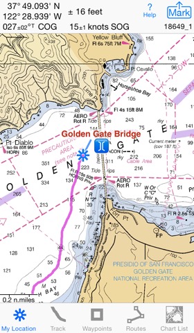
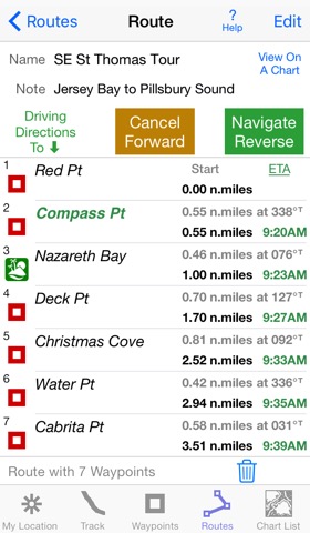
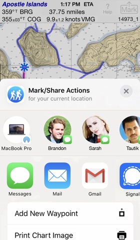
• You don't just see waypoints and routes displayed on the chart, you can actually do real great circle navigation to those waypoints and along those routes. You get information such as Estimated Time of Arrival, current bearing, heading and cross-track error, and remaining distances to your intermediate and final destinations.

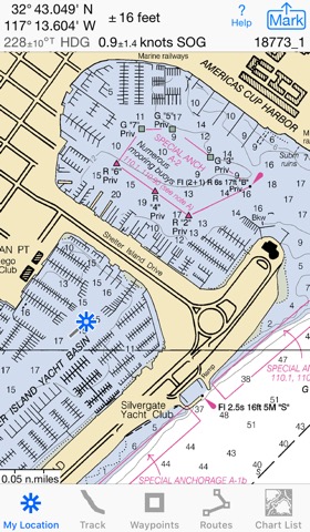
• You don't just see individual charts. Whenever the map projection is compatible (which it is most cases), you can see adjacent charts with their margins removed stitched together seamlessly, even when the chart scales are different. For example you can see the approach chart and the corresponding harbor detail chart both together on the same screen.

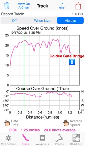
• You can create, import, edit, export, and navigate both on routes based on a recorded or imported path, and on routes based on a series of waypoints.

• iSailGPS's code size is kept very small by efficient programming so in an emergency, you can download it easily even over a weak cell connection.

• The current version of iSailGPS runs on the latest devices and also on older devices with older versions of iOS , all the way back to devices such as the iPhone 6.

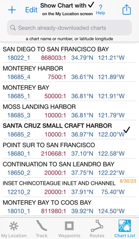
• There is never any confusion over what charts you have available offline. They are clearly listed by NOAA chart name and number, and shown on an overview map.

• Check the App Privacy section. We don't know who you are when you are using iSailGPS. We never send your current location or your recorded track to our servers. Hence we cannot and don't use your location data. We cannot and don't provide your location data to anyone else. Unlike other mapping apps that profit from using your location data in ways that do not keep it private, iSailGPS maintains the highest level of data confidentially.

使い方や遊び方

Unleash the navigation potential of your iPhone or iPad with SailGPS! Turn your device into a high-performance GPS receiver with USA NOAA Raster Nautical Charts, even without a cell signal!


Rated “Best Choice — Excellent” by Practical-Sailor.com


Caught in a storm on the water and your chart plotter fails? Don't worry! Download this app now and regain full navigation capabilities to safely return to port. Better yet, buy iSailGPS today ensuring you're prepared for any situation, even in areas with no cell service.


iSailGPS eliminates sign-ups, ads, subscriptions and in-app purchases, making it more affordable, hassle-free & respectful of your privacy.


Unrivaled Features to Enhance Your Journey:


TRACKS, WAYPOINTS & ROUTES


Record tracks as you sail, even in the background. View them on the chart and in a Speed & Course Over Ground graph.


Mark waypoints precisely using topo or satellite maps, place names or addresses, geotagged photos, or by projecting from a known point.


Set a quick GoTo waypoint or a full route and see the course (COG), heading (HDG), bearing (BRG), direction, distance, cross track error (XTE), Velocity Made Good (VMG) and Estimated Time of Arrival (ETA) at your destination and intermediate points. Perfect for racing enthusiasts.


In a Man Overboard (MOB) emergency a single button press marks your current position & starts navigating to it.


Create customized routes using waypoints, recorded tracks, or imported GPX, KML or TCX files. Advanced route editing.


Send GPX and KML waypoint, route, track and map list files via AirDrop, eMail, Messages, or iCloud Drive.


View the sun & moon position, rise times & set times for any date & place on earth.


Send data to other apps such as Google Earth.


USA NOAA RASTER NAUTICAL CHARTS


Access to all NOAA RNC Charts for USA waters with no extra charge. Download using WiFi or cell service.


Our chart files are optimized to download faster & use less storage memory. Store up to 2200 charts to use anytime at sea without cell service.


Stitches charts & automatically switches between downloaded charts as you sail. Choose detailed or overview charts.


Print & Share chart images overlaid with waypoints, routes & tracks.


Measure distance & direction between any 2 points.


NOAA charts don't include most inland rivers & small lakes. Use our iHikeGPS app for these.


HOW TOS


Tap Help in the app.
Online Manual: isailgps.com
Email developer: lwjames@isailgps.com


RASTER CHARTS VS. VECTOR CHARTS


The National Oceanic & Atmospheric Administration provides both RNC (raster) & ENC (vector) charts.


The great advantage of the high resolution RNC charts used by iSailGPS is the high level of detail produced by professional cartographers that is unobtainable on any vector-based chart. ENC Vector Charts only show a coastline, water depth, navigation aids & minimal details.


These RNC Charts differ from vector charts in that each chart covers a specific area, just as paper nautical charts do. Switches automatically to a new chart when your boat leaves the area covered by the previous chart. For most locations, there are multiple charts at different scales with different levels of detail & areas of coverage.


Paper charts can have multiple panels, each showing a different area or scale. Each digital panel is individually displayed by iSailGPS with a north-up orientation.


Other more expensive marine software uses these same RNC charts. iSail GPS is priced to make it readily available to all boating enthusiasts.


Winner of the Practical Sailor Editors’ Choice Award.


DEVICE REQUIREMENTS


Use iSailGPS on any iOS device even if you don't have a cellular data plan for it. iPhones & WiFi+cellular iPads support full navigation. For WiFi-only iPads & iPod touch, an iOS-compatible external GPS receiver is required to show your location on the water & record tracks. However, you can view charts using the iOS device alone.


Discover a safer and more enjoyable sailing experience with iSailGPS!

最新ストアランキングと月間ランキング推移

iSailGPS : NOAA USA RNC ChartsのiPhoneアプリランキングや、利用者のリアルな声や国内や海外のSNSやインターネットでの人気状況を分析しています。

基本情報

仕様・スペック

対応OS
12.0 以降
容量
10.6 M
推奨年齢
全年齢
アプリ内課金
なし
更新日
2024/03/07

リリース日
2011/04/29

集客動向・アクティブユーザー分析

オーガニック流入


アクティブ率


※この結果はiSailGPS : NOAA USA RNC Chartsのユーザー解析データに基づいています。

利用者の属性・世代

アプリ解析デモグラフィックデータ(男女年代比率52%)

実におもしろい

デモグラフィックデータを元にユーザー層の性別や年齢分布などを考慮して推定しています。

ネット話題指数

開発会社の配信タイトル

このアプリと同一カテゴリのランキング

天使がくれたマカロン
フランソワ
amazon

James Associates Inc. のアプリ

James Associates Inc. の配信アプリ >

新着おすすめアプリ

新着おすすめアプリ >

注目まとめ

iPhoneアプリまとめ >