アプリオンは、世界のアプリランキングや口コミから、おすすめアプリをまとめている人気アプリ探しサイトです。

Iphigénie | The Hiking Map App [iPhone]

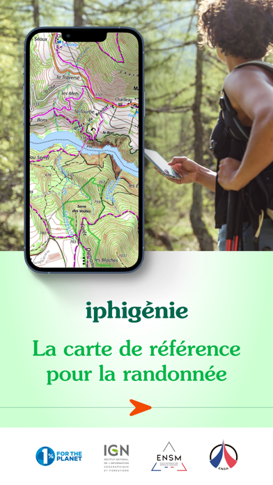
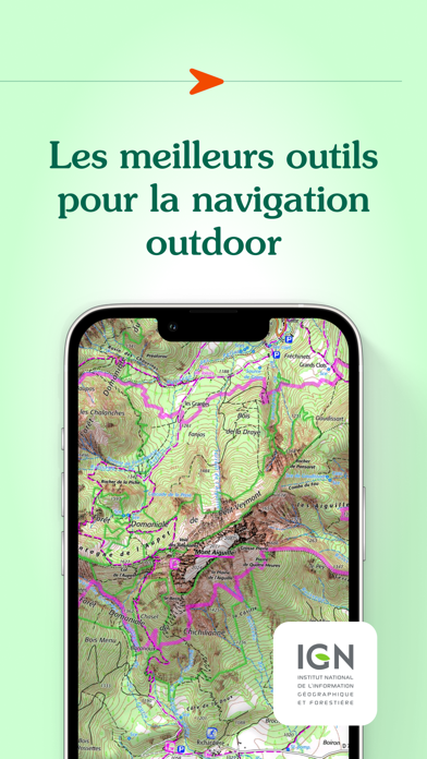
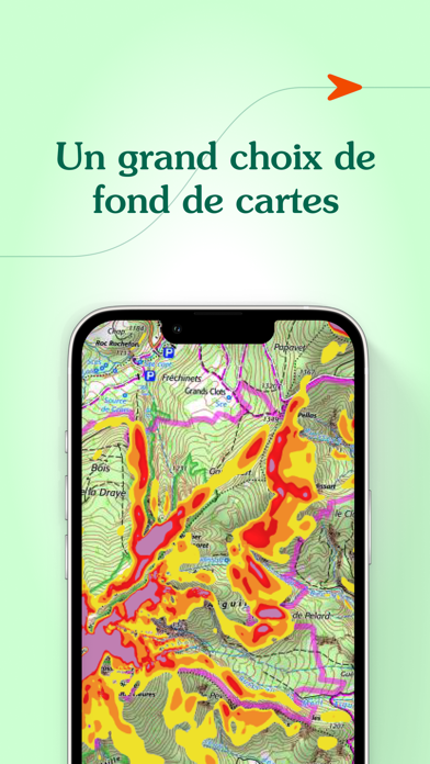
Iphigenieが配信するiPhoneアプリ「Iphigénie | The Hiking Map App」の評価や口コミやランキング推移情報です。このアプリには「ナビゲーション」「スポーツ」などのジャンルで分類しています。APPLIONでは「Iphigénie | The Hiking Map App」の他にもあなたにおすすめのアプリのレビューやみんなの評価や世界ランキングなどから探すことができます。

Iphigénie | The Hiking Map Appのおすすめ画像1
Iphigénie | The Hiking Map Appのおすすめ画像2
Iphigénie | The Hiking Map Appのおすすめ画像3
Iphigénie | The Hiking Map Appのおすすめ画像4
Iphigénie | The Hiking Map Appのおすすめ画像5
<
>

Iphigenieの地図/ナビアプリ

「Iphigénie | The Hiking Map App」は、Iphigenieが配信する地図/ナビアプリです。

ナビゲーション スポーツ

このアプリの話題とニュース

  • 新バージョン13.0.2が配信開始。新機能や改善アップデートがされています。(3/22)


  • 2010年4月5日(月)にiPhoneとiPad両対応のユニバーサルアプリとしてリリース!


最新更新情報

version13.0.2が、2024年3月22日(金)にリリース

IGN data migration final version:
- Migration of the IGN altimeter service.
- Bug fix on iOS 16 and previous on search function
- Bug fix on iOS 12 and previous. App no longer crashes

使い方や遊び方

Iphigénie is the hiking map app for outdoor enthusiasts in France and around the world. Perfect for individuals (hikers, trailers, bikers, horse riders…) and professionals (guides, firefighters, surveyors, airmen, sailors, etc.) who need accurate maps.


Find more than 40 detailed topographic basemaps (including IGN maps, SwissTopo, IGN Spain, OpenTopo, OpenSnow, land registry, slope inclination), even while offline.


BEFORE YOUR OUTING
- Prepare your outing by downloading maps to access them offline
- Create, edit and import tracks
- Create and import markers (e.g. mushroom spots, departure points of routes, etc.)
- Print sections of the map if you need to
- Search for a specific location by name or by GPS details
- Access routes or landmarks from IGNRando or Data-Avalanche
- Access a 3D view and slope inclinations


DURING YOUR OUTING
- Geolocate yourself on the basemap of your choice
- Follow routes using GPS, without worrying about network availability
- Record your track
- Access real-time information such as distance traveled, elevation (±), average speed, current speed, estimated time of arrival, etc.
- Activate the beacon function to allow your loved ones to follow your progress in real-time
- Create specific voice alerts to guide you, even with your iPhone in your pocket


AFTER YOUR OUTING
- Create groups of tracks/landmarks
- Store and backup all your data in the Cloud
- Export your GPS tracks and landmarks in GPX format
- Share your outings and landmarks with all your friends


What our customers say about us:
" Thanks to Iphigénie, I discover a lot of amazing new places. I note the slopes, the summits, the lakes... It saves me precious time, especially in remote places where there are very few indications and markings! ".


In the press :
20 minutes: " Hiking, like outdoor activities, has not missed the digital shift, as Alice (25) comments. "It's hugely appreciated to be able to check accurate IGN maps, including when you no longer have a connection, as happens a lot in the high mountains".


Download the free basic app
Download the basic application for free on your smartphone. This version allows you to be geolocated on one of the 25 free base maps such as Open Topo Map, Open Cycle Map, Open Snow map. The world is within reach!
You will also have access to real-time information such as your position/course/altitude/speed.


Download the complete app with the “Iphigénie Carto” subscription
The Iphigénie Carto subscription is €24.99 per year. It gives you access to 40 base maps including those of IGN. These maps can be downloaded on your device (iPhone, iPad, iPod, Watch) so that you can access them even without a network.
‍You also have access to the full potential of Iphigénie by finding all the features mentioned above.


Good to know: you have 7 days to test the complete app for free.


List of available maps:
- IGN France
- SwissTopo
- IGN Spain
- IGN Belgium
- BKG Germany
- Kartverket Norway
- Cartographic Institute of Catalunya
- OpenTopo
- OpenCycle
- OpenSnow
- ICAO
- ESRI
- Satellite view
- Cadastre
- Slope inclination
- Restricted areas for drones
- Historical maps of France
- Geological and mining maps (France)
- National Forestry Office


We donate 1% of our turnover to 1% for the Planet to help preserve the environment.


MADE IN FRANCE

カスタマーレビュー・評価

3.0
5つ星
 
0
4つ星
 
0
3つ星
 
1
2つ星
 
0
1つ星
 
0

最新ストアランキングと月間ランキング推移

Iphigénie | The Hiking Map AppのiPhoneアプリランキングや、利用者のリアルな声や国内や海外のSNSやインターネットでの人気状況を分析しています。

基本情報

仕様・スペック

対応OS
9.0 以降
容量
94.4 M
推奨年齢
全年齢
アプリ内課金
あり
更新日
2024/03/22

リリース日
2010/04/05

集客動向・アクティブユーザー分析

オーガニック流入


アクティブ率


※この結果はIphigénie | The Hiking Map Appのユーザー解析データに基づいています。

アプリ内課金の売れ筋ランキング

  • 1位: Geoportail (1800円)

  • 2位: iPhiGéNie Vmax (700円)

  • 3位: Cartoweb topo Belgium (1200円)

  • 4位: Iphigénie Carto subscription (2800円)

利用者の属性・世代

アプリ解析デモグラフィックデータ(男女年代比率52%)

ゲッツ!!

デモグラフィックデータを元にユーザー層の性別や年齢分布などを考慮して推定しています。

ネット話題指数

開発会社の配信タイトル

このアプリと同一カテゴリのランキング

桃太郎電鉄ワールド ~地球は希望でまわってる!~
コナミデジタルエンタテインメント
amazon

新着おすすめアプリ

新着おすすめアプリ >

注目まとめ

iPhoneアプリまとめ >

ダウンロード数が多いおすすめアプリ

無料ゲームアプリランキング >