アプリオンは、世界のアプリランキングや口コミから、おすすめアプリをまとめている人気アプリ探しサイトです。
アプリオンは、世界のアプリランキングや口コミから、おすすめアプリをまとめている人気アプリ探しサイトです。
Zirak s.r.l.が配信するiPhoneアプリ「EasyTrails GPS」の評価や口コミやランキング推移情報です。このアプリには「スポーツ」「ナビゲーション」などのジャンルで分類しています。APPLIONでは「EasyTrails GPS」の他にもあなたにおすすめのアプリのレビューやみんなの評価や世界ランキングなどから探すことができます。

EasyTrails GPS
Zirak s.r.l.
¥600
iPhone / iPad対応
スポーツ
ナビゲーション
64bit
|
86 Trend |

このアプリの話題とニュース
新バージョン11.4が配信開始。新機能や改善アップデートがされています。(1/16)
2009年8月14日(金)にiPhoneとiPad両対応のユニバーサルアプリとしてリリース!
このレビュアーのおすすめコメント
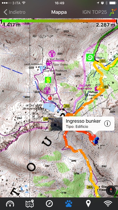
山歩きの記録を残しておきたくて、
今日までに5回使って見ましたが、期待どおり、
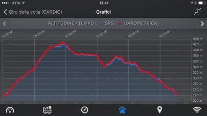
ルートと標高の記録ができます。
アイコン等の色彩の美しさや、時折凝った(おちゃめ)部分にヨーロッパぽさを感じ、わたし的に好感度高いです。
iPhoneでデータを取って、メイルなどを介してiPadにインポートして眺めようとすると、気圧計のデータが無くなるのがやや残念ですが、まあ、MUSTの部分じゃあないです。
イタリア贔屓で無くても - ★★★★☆
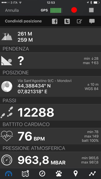
操作性、機能性、省電力性どれをとっても最高のアプリ。
キリマンジャロで使用しましたが、iPhoneではロガーとしてではなく標高確認用として、iPadではロガーとして使用しました。
iPhoneは見たいときだけ開いて見ていましたが全然バッテリーは減りませんでした。
iPadは他の機能全部切って約3日は余裕で持ちました。
出力機能も申し分なく、過去使ってきたどのロガーアプリよりもよかったです。
最高のGPSロガーアプリ - ★★★★★
レビューを見てフリー版を使い、その後で購入決意しました。
概ね満足です。
スリープモードでログ取りしてくれるのは画期的ですね。
でもさすがに他のアプリ立ち上げ中は自動的に中断になるようです。
中断箇所と再開箇所を適当に繋げてくれる選択肢があればなお良いとおもいます。
GPSは、建物の中だとなかなか認識してくれない気がしますが実質的にはあまり問題ではありません。
イイ感じです。 - ★★★★☆
最新更新情報
version11.4が、2024年1月16日(火)にリリース
fix: app layout on newer iPhone devices
|
5つ星
7
4つ星
3
3つ星
2
2つ星
0
1つ星
0
|
おすすめ口コミ
Dropboxとの連携!
英語表示ですが使い方が分かりやすくていいですね。とくに、Dropboxと連携できるとこが気に入ってます。
ちょっとした要望ですが、記録後のファイル名をあとあと変更できると助かります。とりあえずsaveすることが多いので…。
anti-entro - ★★★★★ 2012-04-29
申し分ありません
ログもほぼ正確ですし、スリープ中でもログ取りできますので、電池も持ちます。チャートも充実しているので、人にログを見せる時も受けがいいです。
すばっち - ★★★★★ 2009-09-12
いいのを見つけた
色々と使って来たが、これは使いやすい。
簡単操作です。
記録利用もやりやすい。
vesti - ★★★★★ 2009-12-07
EasyTrails GPSのiPhoneアプリランキングや、利用者のリアルな声や国内や海外のSNSやインターネットでの人気状況を分析しています。
|
|
※この結果はEasyTrails GPSのユーザー解析データに基づいています。
1位: Colored tracks (100円)
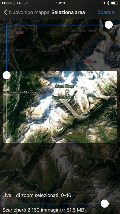
2位: Download maps (300円)
3位: Heart rate monitoring (300円)
4位: iWatch Remote (300円)
5位: Cloud storage (380円)
![]()
実におもしろい
※デモグラフィックデータを元にユーザー層の性別や年齢分布などを考慮して推定しています。

¥400→¥100 : 地下鉄に乗って過去と未来を行き来しながら、ローラの人生を表す駅を探索し、その記憶を辿っていく、パズルアドベンチャーゲーム『Underground Blossom』が75%オフの大幅値下げ!
2024年04月20日 01:10

¥100→無料 : F-35などの戦闘機に搭乗して、空中戦やデスマッチを繰り広げる、3Dフライトシューティングゲーム『Carrier Landing HD』が無料セール!
2024年04月18日 16:15

瞳を「ぐるぐる目」にしてくれる、可愛い顔写真に加工できる自撮り美肌カメラ『美顔相機』が人気アプリとして話題沸騰!
2024年04月18日 11:00

露出変更やシャッタースピード、6倍ズームなどプロのように撮れる高機能カメラアプリ『ProCamera』が使えるアプリとして注目を集める
2024年04月17日 11:00
立体の切り口や、思考力を高める教材が詰まった、空間認識力や図形知識など考える力を蓄えられる、脳トレパズルゲーム『シンクシンク』がAppStoreの今日のアプリに掲載され注目作に
2024年04月19日 18:00