アプリオンは、世界のアプリランキングや口コミから、おすすめアプリをまとめている人気アプリ探しサイトです。
アプリオンは、世界のアプリランキングや口コミから、おすすめアプリをまとめている人気アプリ探しサイトです。
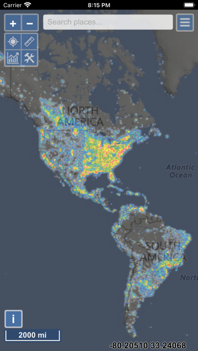
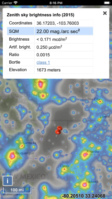
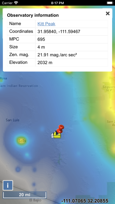
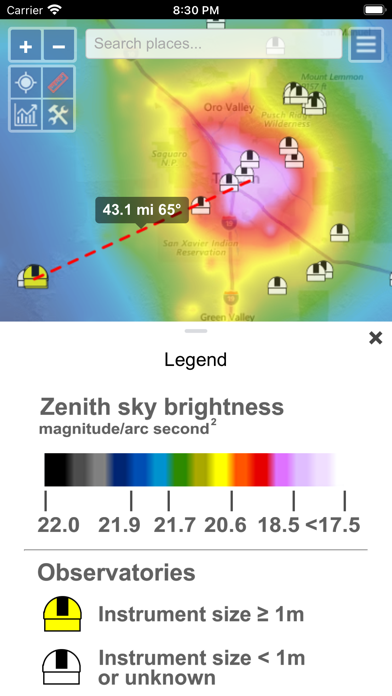
Jurij Stareが配信するiPhoneアプリ「Light Pollution Map」の評価や口コミやランキング推移情報です。このアプリには「ナビゲーション」「ユーティリティ」などのジャンルで分類しています。APPLIONでは「Light Pollution Map」の他にもあなたにおすすめのアプリのレビューやみんなの評価や世界ランキングなどから探すことができます。

Light Pollution Map
Jurij Stare
¥800
iPhone / iPad対応
ナビゲーション
ユーティリティ
64bit
|
89 Trend |


このアプリの話題とニュース
新バージョン1.1.21が配信開始。新機能や改善アップデートがされています。(8/18)
2020年9月20日(日)にiPhoneとiPad両対応のユニバーサルアプリとしてリリース!
最新更新情報
version1.1.21が、2023年8月18日(金)にリリース
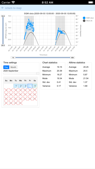
- VIIRS chart now has an option to display monthly values
- Fixed trailing artefact produced by the popup window on some devices
- Fixed the issue of previously downloaded offline maps not showing after app update
- Fixed the issue of search bar not showing when there are too many users on the server
|
5つ星
4
4つ星
0
3つ星
0
2つ星
0
1つ星
1
|
Light Pollution MapのiPhoneアプリランキングや、利用者のリアルな声や国内や海外のSNSやインターネットでの人気状況を分析しています。
|
|
※この結果はLight Pollution Mapのユーザー解析データに基づいています。
![]()
・・・だが断るッ!!
※デモグラフィックデータを元にユーザー層の性別や年齢分布などを考慮して推定しています。

¥600→¥100 : 「moon」を制作したコンビが贈る、奇妙なホテルでオニオンスープにまつわる不思議な話が展開する、アクションパズル&アドベンチャーゲーム『Million Onion Hotel』が84%オフの大幅値下げ!
2024年04月18日 16:10

露出変更やシャッタースピード、6倍ズームなどプロのように撮れる高機能カメラアプリ『ProCamera』が使えるアプリとして注目を集める
2024年04月17日 11:00

線路を引いて、オリジナルの列車で走る、キッズ向け電車ゲーム『BRIO World』が子どもやファミリー層に人気に
2024年04月19日 10:00

【新作】戦艦を操縦し、敵艦艇を主砲や副砲で沈めるため戦う、3D海戦シューティングゲーム『World of Warships: Legends PvP』のiOS版がリリース!
2024年04月16日 16:00

タスクや勉強をやる時間を決めて、時間をはかりながら集中してやりきる、タイムトラッキングアプリ『目標達成タイマー』がネットで取り上げられ話題に
2024年04月18日 08:00
![[777Real]新世紀エヴァンゲリオン ~未来への咆哮~ - iPhoneアプリ](https://is1-ssl.mzstatic.com/image/thumb/Purple126/v4/7c/dc/e6/7cdce656-1653-cbbb-43fa-df6c516071c7/AppIcon-0-0-1x_U007emarketing-0-0-0-6-0-0-sRGB-0-0-0-GLES2_U002c0-512MB-85-220-0-0.png/100x100bb.jpg)