アプリオンは、世界のアプリランキングや口コミから、おすすめアプリをまとめている人気アプリ探しサイトです。
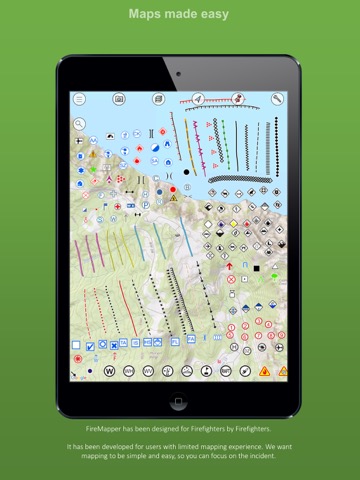
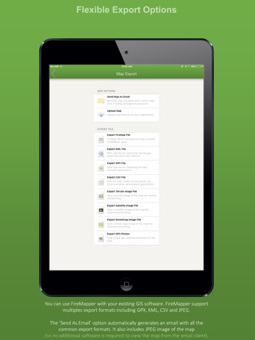
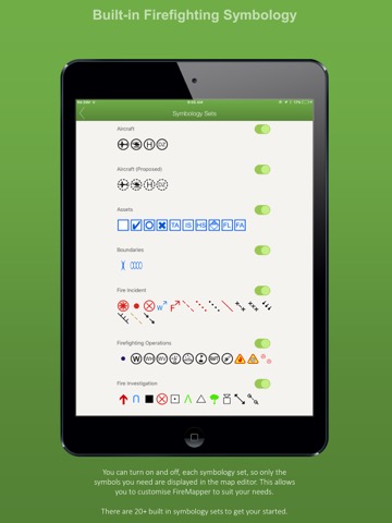
FireMapper [iPad]

FireMapperのおすすめ画像1
FireMapperのおすすめ画像2
FireMapperのおすすめ画像3
FireMapperのおすすめ画像4
FireMapperのおすすめ画像5
FireMapperのおすすめ画像6
FireMapperのおすすめ画像7
<
>

Fire Front Solutions Pty Ltdの地図/ナビアプリ

「FireMapper」は、Fire Front Solutions Pty Ltdが配信する地図/ナビアプリです。

ナビゲーション ユーティリティ

このアプリの話題とニュース

  • 新バージョン1.258が配信開始。新機能や改善アップデートがされています。(5/12)


  • 2014年4月25日(金)にiPhoneとiPad両対応のユニバーサルアプリとしてリリース!


最新更新情報

version1.258が、2023年5月12日(金)にリリース

-> drop down menu on the main menu

使い方や遊び方

FireMapper is designed for firefighters for quickly generating bushfire and other incident maps. The applications provides a simple interface for drawing maps and exporting via Email.


Maps are stored on the local device and can be created or used offline. No internet connection is required for collecting data.


FACEBOOK & SUPPORT:
Like us on Facebook to be notified of future updates and developments.
http://www.facebook.com/FireMapperApp


MAP EXPORT FORMATS:
Multiple points can be drawn on the map and exported in the same email. The map data can be exported as:


* GPX (suitable for ArcGIS, MapDesk and other popular GIS products, QGIS)
* KML (suitable for Google Maps & Google Earth)
* CSV (suitable for Microsoft Excel & Google Spreadsheets)
* JPG (photo of the map)


You can also send points & lines as a text message.


GPS CAMERA:
Take geo-referenced photos and display the location and bearing on the map.


GPS RECORDING:
FireMapper supports GPS recording in the background. Continued use of GPS running in the background can dramatically decrease battery life.


BUSHFIRE SYMBOLS:
This version contains bush firefighting symbols that are commonly used in Australia, USA & Canada with support for:
* National All Hazards Symbology Set
* USA Interagency Wildfire Point Symbols


Including the following icons:
Hydrant, Water Point, Fire Origin, Spot Fire, Aerial Ignition, Hotspot, Defendable/Not Defendable Asset, Threatened Asset, Indigenous Site, Historic Site, Hazmat,Flora/Fauna, Airbase, Helibase, Helibase,Smoker Standing/Down,Tree Down, Medical, Mobile Weather Station, Portable Communications, Access Point, Control Point, Road Closure, RAFT, Drop Zone, Assembly area, Staging area, Base camp, Control Centre, Divisonal/Sector Command, Evacuation Area/Center, Escape Route, Refuge area, Property damage and more....


LOCATION FORMATS:
-Latitude/Longitude (Decimal Degrees and Degree Minutes/Aviation)
- UTM Coordinates
- 1:25 000, 1:50 000 & 1:100 000 map sheet references
- UBD Map References (Sydney, Canberra, Adelaide, Perth)


INTEGRATED SEARCH:
Search by address, suburb, latitude/longitude, utm coordinates, grid references, place name, point type and more.


OFFLINE SUPPORT:
Maps can be created offline without an internet connection. Map layers are cached for offline support


MULTIPLE MAP LAYERS:
- Standard
- Satellite/Hybrid
- Terrain/Topographic
- US Topographic
- Australian Topographic
- NZ Topographic
and more....

最新ストアランキングと月間ランキング推移

FireMapperのiPadアプリランキングや、利用者のリアルな声や国内や海外のSNSやインターネットでの人気状況を分析しています。

基本情報

仕様・スペック

対応OS
12.0 以降
容量
33.9 M
推奨年齢
全年齢
アプリ内課金
なし
更新日
2023/05/12

リリース日
2014/04/25

集客動向・アクティブユーザー分析

オーガニック流入


アクティブ率


※この結果はFireMapperのユーザー解析データに基づいています。

利用者の属性・世代

アプリ解析デモグラフィックデータ(男女年代比率52%)

実におもしろい

デモグラフィックデータを元にユーザー層の性別や年齢分布などを考慮して推定しています。

ネット話題指数

開発会社の配信タイトル

このアプリと同一カテゴリのランキング

のっけるふりかけ 鮭明太
丸美屋
amazon

Fire Front Solutions Pty Ltd のアプリ

Fire Front Solutions Pty Ltd の配信アプリ >

新着おすすめアプリ

新着おすすめアプリ >

注目まとめ

iPadアプリまとめ >