アプリオンは、世界のアプリランキングや口コミから、おすすめアプリをまとめている人気アプリ探しサイトです。
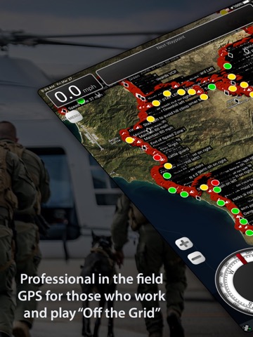
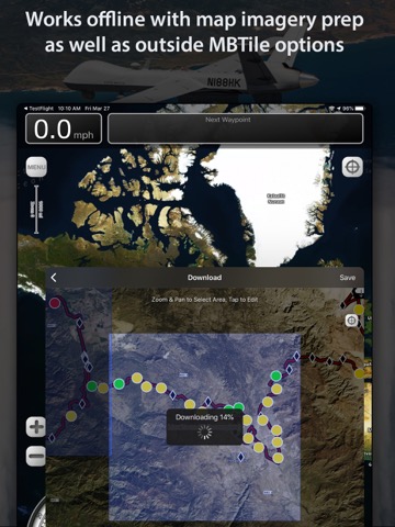
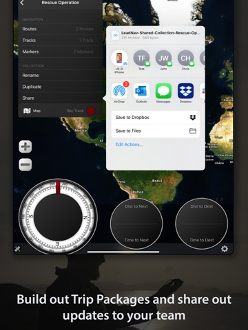
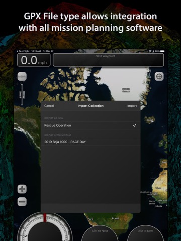
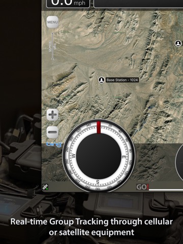
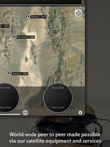
LeadNav GPS [iPad]

LeadNav GPSのおすすめ画像1
LeadNav GPSのおすすめ画像2
LeadNav GPSのおすすめ画像3
LeadNav GPSのおすすめ画像4
LeadNav GPSのおすすめ画像5
LeadNav GPSのおすすめ画像6
LeadNav GPSのおすすめ画像7
LeadNav GPSのおすすめ画像8
LeadNav GPSのおすすめ画像9
<
>

LeadNav Systems LLCの地図/ナビアプリ

「LeadNav GPS」は、LeadNav Systems LLCが配信する地図/ナビアプリです。

ナビゲーション スポーツ

このアプリの話題とニュース

  • 新バージョン6.13が配信開始。新機能や改善アップデートがされています。


  • 2013年10月1日(火)にiPhoneとiPad両対応のユニバーサルアプリとしてリリース!


最新更新情報

version6.13が、2022年4月8日(金)にリリース

Some fixes reported by our operators in the field

- Fixed issues with the UTM coordinate format and made it easier to enter in those coordinates
- Minor bug fixes

We appreciate your feedback so please take the time and give us a review!

使い方や遊び方

Mission Planning, Coordination, Communication and GPS Navigation for those who Work and Play "Off the Grid”


Built by operators for operators, with decades of experience leading technology innovation in the field.


Focused on mobility into dismounted foot patrol operations, LEADNAV currently provides full mission packages in the form of Software, Hardware, Training and Consulting for those operating in some of the harshest conditions and environments imaginable.


Used by many, to include off-roaders, security and response teams and other Professional Organizations World Wide!


More Powerful than any other GPS on the Market!


Features:


• Plan, Organize, Coordinate and Execute Trips, Events and other Professional Operations.


• Create or Import Collections of Routes, Tracks, and Markers for different events. (Baja 1000 2019, Mining Expedition 2020)


• Share individual Routes, Tracks, and Markers amongst your Team or Group.


• Easy to use point to point Route Planning Interface. Plan your route and go!


• Drop audible warnings and non-audible Serpentine points to keep you on track.


• Record tracks to display where you have been. So you can hit the trail again or find your way back. You can also convert your tracks to routes. Track Stats for each trip.


• Highly advanced Team Location Tracking through our cellular/wifi, preprogrammed Iridium GO! units (Satellite device and our service plans) and other specialized equipment under contract.


• Reverse your routes. Hike to the top and then reverse the route to hike back down!


• Drop Markers to identify places of interest or to document the experience as you go. Vehicle, rally point, boat dock, deer, or anything else you want to find again.


• System functions on the GPX file standard


• Free online Map Sources include Bing, OpenStreetMap, USGS Satellite and USGS Topo

• Support of offline mapping options like MBTiles and overlays with our Pro Pack subscription and contracted services.


• Subscriptions allow access to additional features and maps (Mapbox Satellite, Mapbox Terrain, Mapbox Streets), and access to your own URL entry (Part of the Pro Subscription). Create, cache, and delete maps with your custom URLs. *Maps subject to change by the providers


• Offline Mapping for areas with no cellular coverage. (yearly subscriptions) Select and store desired areas of the map for offline use. Download those maps before you go in the field!


• Compatible with Bluetooth headsets and speakers for eyes free navigation. Throw your device in your pack and GO!


• Voice Prompts automatically adjust for the current speed. Siri now reads the waypoint label names as you navigate. “Big freaking rock on the left!” Get creative with the names to make the most out of your experience.


• Automatically adjusts your audible (Red) Turn Warning and (Blue) Waypoint Proximity rings based off of your current speed. Giving you the information you need when you need it.


Audio Guidance Examples:


“Slight Left in 450 meters” ...... “Slight Left”


“Danger in 500 meters” ....... "Danger"


—————————————————


Additional In-App Purchases: (See website for all subscription details)


- Advanced Pack Subscription (recommended for those on foot covering smaller areas)
- Pro Pack Subscription (recommended for those in vehicles covering larger areas or needing our more pro level features listed on our website)

- Recon Markers
- Hunting Markers
- Aviation Markers


Note:


• This is a high powered GPS device and requires power connectivity for prolonged use in the field.


• Mobile devices that are WiFi only do not come with an internal GPS. An external GPS will need to be used along with the application.


• The capability to save satellite maps/imagery to your device for "off the grid" use is an outside service and requires a yearly Subscription


Battery Life Disclaimer: Continued use of GPS running in the background can dramatically decrease battery life.

最新ストアランキングと月間ランキング推移

LeadNav GPSのiPadアプリランキングや、利用者のリアルな声や国内や海外のSNSやインターネットでの人気状況を分析しています。

基本情報

仕様・スペック

対応OS
11.4 以降
容量
140 M
推奨年齢
全年齢
アプリ内課金
あり
更新日
2022/04/08

リリース日
2013/10/01

集客動向・アクティブユーザー分析

オーガニック流入


アクティブ率


※この結果はLeadNav GPSのユーザー解析データに基づいています。

アプリ内課金の売れ筋ランキング

  • 1位: Satellite Group Tracking (74800円)

  • 2位: Satellite Group Tracking (16400円)

  • 3位: Pro Pack Yearly (26800円)

  • 4位: Advanced Pack Yearly (7600円)

  • 5位: Advanced to Pro Upgrade (25000円)

  • 6位: Advanced Subscription (1 Year) (10000円)

  • 7位: Map to Pro Upgrade (30000円)

  • 8位: Advanced Pack (1Year Subscription) - Map to Advanced Upgrade (3000円)

  • 9位: Recon Markers (700円)

  • 10位: Aviation Markers (700円)

利用者の属性・世代

アプリ解析デモグラフィックデータ(男女年代比率52%)

ちょっ待てよ

デモグラフィックデータを元にユーザー層の性別や年齢分布などを考慮して推定しています。

ネット話題指数

開発会社の配信タイトル

このアプリと同一カテゴリのランキング

マリオカート8
任天堂
amazon

新着おすすめアプリ

新着おすすめアプリ >

注目まとめ

iPadアプリまとめ >

ダウンロード数が多いおすすめアプリ

無料ゲームアプリランキング >