アプリオンは、世界のアプリランキングや口コミから、おすすめアプリをまとめている人気アプリ探しサイトです。
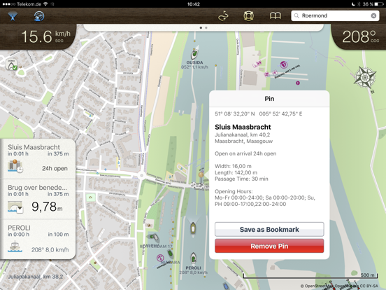
Rivers & Seas [iPad]

Rivers & Seasのおすすめ画像1
Rivers & Seasのおすすめ画像2
Rivers & Seasのおすすめ画像3
Rivers & Seasのおすすめ画像4
Rivers & Seasのおすすめ画像5
Rivers & Seasのおすすめ画像6
<
>

mediaworx berlin AGの地図/ナビアプリ

「Rivers & Seas」は、mediaworx berlin AGが配信する地図/ナビアプリです。

ナビゲーション 旅行

このアプリの話題とニュース

  • 新バージョン1.5.1が配信開始。新機能や改善アップデートがされています。


  • 2012年5月10日(木)にiPad版がリリース!


最新更新情報

version1.5.1が、2021年1月30日(土)にリリース

This update fixes the crash under iOS 14 and makes Rivers & Seas using the full screen on iPad Pro.

Minor changes:
- Problems using Dark Mode have been fixed
- Own boat is not displayed as a foreign vessel on the chart with "Show ships"
- Retina mode has been removed
- Restore Purchases is now inside "Show Ships" activation
- Activation of "Show Ships" is working again
- Smaller fixes and improvements

If you like Rivers & Seas, we'd be happy to see a review in the App Store. :-)

使い方や遊び方

The chart plotter with AIS for inland waters. Rivers & Seas is the iPad navigation system for your boat:

DETAILED WATERS MAPS
Rivers and waterways are listed in detail with buoys, clearances, landmarks, ports and anchorages. In addition landscape, roads and buildings provide orientation. Marinas are shown with piers and service facilities such as gas stations and black water extraction.

AREA GUIDE
VHF channels, phone numbers and opening times of locks and bridges ahead are displayed automatically when driving. You will get a warning if a bridge clearance is too low or a lock will be closed upon arrival.

The display of speed, heading and position also includes the speed limit at the current route segment. Your location is named with river kilometer and name of the river, lake or bay.


SHIP POSITIONS AIS (In App Subscription)
Position of ships with AIS is shown in the map. Ships on the waterway ahead are displayed in the left panel with name , course and speed. No AIS receiver is needed for that.

PLANNED ROUTES
Planned routes can be drawn and used as a guide line for the ride. Rivers & Seas calculates length and travel time of the route. The drawing tool is ideal for routes along winding waterways and chains of lakes.

The planned routes are also ideal on boating holidays for remembering and following the recommendation of a charter basis.

DESTINATIONS AND BOOKMARKS
Rivers & Seas predicts distance and travel time to destinations on the waterway that you mark with pins. The passage time and opening times of locks or bridges are included in the calculation.

OFFLINE MAPS
Routes and areas can be downloaded. Under way or abroad no internet connection is required. Only the areas needed on the route are loaded, without needless land areas.

CLERANCES, OPENING HOURS AND SPEED LIMITS
Bridges and locks on the waterway ahead are displayed in a list with clearances, opening hours, VHF channels and phone numbers along with the distance and remaining driving time to get there. If bridges are to low or locks will be closed upon arrival, a warning is displayed.

FRIENDS RADAR
Even the location of your friends or flotilla is shown in the map. Find anchor position of friends to easily or keep an eye on the distance to the boots of an a convoy with the Friends Radar.

SEARCHING
Search for waters, places, addresses, coordinates and even facilities such as marinas, shops or ATMs.

You will see, Rivers & Seas is the ideal plotter for inland waters. To learn more, visit us at facebook.com/riversandseas or write us at suppport@riversandseas.de.

Rivers & Seas is suitable especially for Germany, Netherlands, France, Austria, Switzerland and Baltic Sea, North Sea, Balearic Islands and the Adriatic Sea. The positon of ships in ma (AIS) is useful all over the world.

The map does not show water depths. The display of clearances, speed limits and river kilometer is only available in German and Dutch inland waters.

Rivers & Seas runs on all iPads. The current GPS position can only be displayed on iPads with cellular data. Continued use of GPS running in the background can dramatically decrease battery life. For long-term use of the iPad as a chart plotter a power source is required.

最新ストアランキングと月間ランキング推移

Rivers & SeasのiPadアプリランキングや、利用者のリアルな声や国内や海外のSNSやインターネットでの人気状況を分析しています。

基本情報

仕様・スペック

対応OS
11.0 以降
容量
16.4 M
推奨年齢
全年齢
アプリ内課金
あり
更新日
2021/01/30

リリース日
2012/05/10

集客動向・アクティブユーザー分析

オーガニック流入


アクティブ率


※この結果はRivers & Seasのユーザー解析データに基づいています。

アプリ内課金の売れ筋ランキング

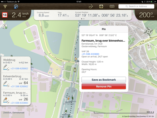
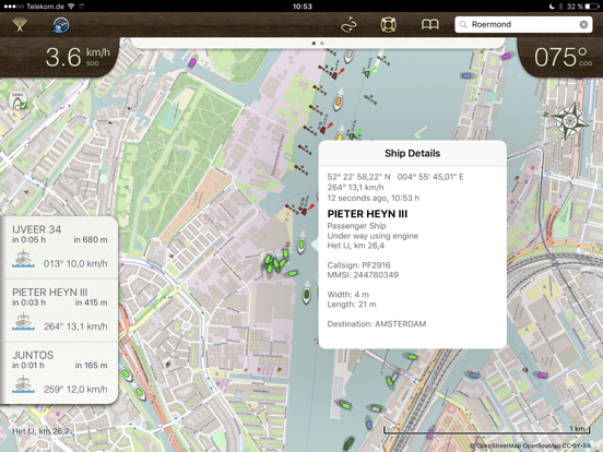
  • 1位: Show ships (250円)

利用者の属性・世代

アプリ解析デモグラフィックデータ(男女年代比率52%)

・・・だが断るッ!!

デモグラフィックデータを元にユーザー層の性別や年齢分布などを考慮して推定しています。

ネット話題指数

開発会社の配信タイトル

このアプリと同一カテゴリのランキング

銀座千疋屋フルーツクーヘン
銀座千疋屋
amazon

新着おすすめアプリ

新着おすすめアプリ >

注目まとめ

iPadアプリまとめ >

ダウンロード数が多いおすすめアプリ

無料ゲームアプリランキング >