アプリオンは、世界のアプリランキングや口コミから、おすすめアプリをまとめている人気アプリ探しサイトです。
アプリオンは、世界のアプリランキングや口コミから、おすすめアプリをまとめている人気アプリ探しサイトです。
「Guthook Guides Australia & New Zealand」は、AtlasGuidesが配信する地図/旅行アプリです。

Guthook Guides Australia & New Zealand
AtlasGuides
無料
Android対応
旅行&地域
|
60 Trend |
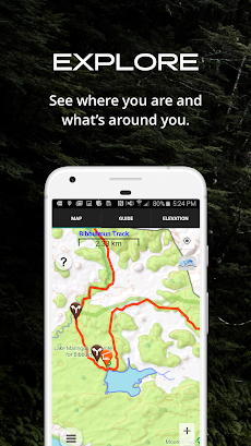
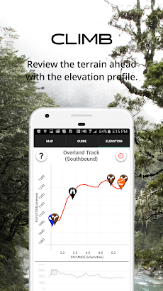
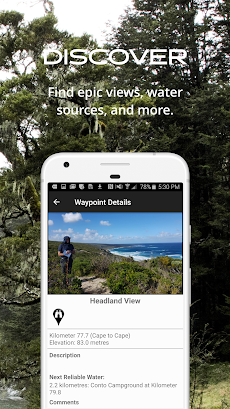
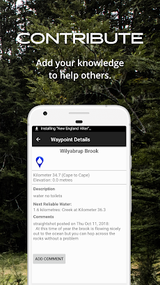
「Guthook Guides Australia & New Zealand」は、AtlasGuidesが配信する地図/旅行アプリです。
このアプリの話題とニュース
最高評価5.0点のレビュー点数がついた優秀なアプリです。(4/25)
新バージョン8.3.8が配信開始。新機能や改善アップデートがされています。
最新更新情報
version8.3.8が、2021年9月22日(水)にリリース
|
5つ星
97
4つ星
0
3つ星
0
2つ星
0
1つ星
0
|
Guthook Guides Australia & New ZealandのAndroidアプリランキングや、利用者のリアルな声や国内や海外のSNSやインターネットでの人気状況を分析しています。
|
|
※この結果はGuthook Guides Australia & New Zealandのユーザー解析データに基づいています。

【新作】土佐弁を話す人魚と、絵しりとりをし、水中に浮かぶ泡の中から次に繋がるイラストを選んでいく、絵しりとりゲーム『えむすび』のAndroid版がリリース!
2024年04月24日 20:00

ストップウォッチ、カウントダウンタイマー、ポモドーロタイマーの3種類のタイマーを搭載した、勉強時間計測アプリ『Focusi』がネットで取り上げられ話題に
2024年04月25日 08:00

【新作】1枚のイラストの中に隠された本当の意味を見つけ出す、『違和感ミステリー』のAndroid版が配信開始!
2024年04月23日 12:00

それぞれの技を持つ4人のキャラクターを選び、衣装を着せ、スケートリンクで技を決める、キッズ向けアイススケートゲーム『Nice Skating』が子どもやファミリー層に人気に
2024年04月25日 10:00

【新作】無人島を開拓して、農場などを作り住める島に作り上げていく、開拓シミュレーションゲーム『Horizon Island: Farm Adventure』のAndroid版が配信開始!
2024年04月23日 16:00
