アプリオンは、世界のアプリランキングや口コミから、おすすめアプリをまとめている人気アプリ探しサイトです。
アプリオンは、世界のアプリランキングや口コミから、おすすめアプリをまとめている人気アプリ探しサイトです。
ForeFlightが配信するiPhoneアプリ「ForeFlight Mobile EFB」の評価や口コミやランキング推移情報です。このアプリには「天気」「ナビゲーション」などのジャンルで分類しています。APPLIONでは「ForeFlight Mobile EFB」の他にもあなたにおすすめのアプリのレビューやみんなの評価や世界ランキングなどから探すことができます。

ForeFlight Mobile EFB
ForeFlight
無料
iPhone / iPad対応
|
88 Trend |


このアプリの話題とニュース
新バージョン16.4が配信開始。新機能や改善アップデートがされています。(4/23)
2009年12月18日(金)にiPhoneとiPad両対応のユニバーサルアプリとしてリリース!
このレビュアーのおすすめコメント
料金はそこそこしますが、無料版でも情報が思うように取れます。
空関係のお仕事の際に、事前情報として見るには便利です。
optionが高価なので、、、☆4個
iPadでも使えます。 - ★★★★☆
最新更新情報
version16.4が、2024年4月23日(火)にリリース
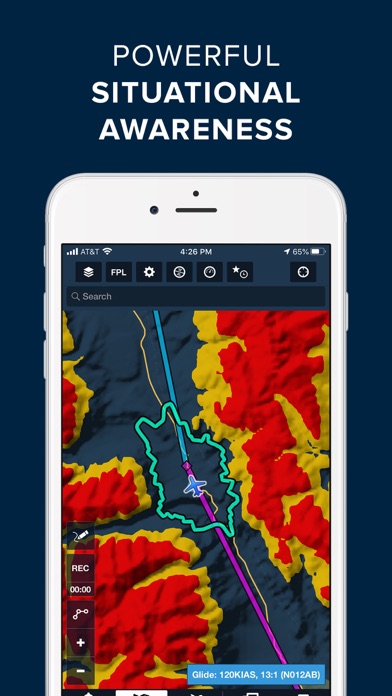
Reported Turbulence Map Layer
• Plan smoother and safer flights by seeing where pilots are actually encountering smooth air or turbulence with this powerful new map layer.
• The layer displays individual turbulence reports as color-coded dots representing turbulence intensity, which you can tap on to view the report’s age (up to approximately six hours old), altitude, airspeed, and the type code and wake category of the aircraft from which the report originated, as well as a list of nearby reports.
• An altitude slider is available to filter turbulence reports by altitude, and the Reported Turbulence layer is also available in Profile View, allowing you to view reports at all altitudes along your planned route.
• The new layer receives its data from Sentry and Sentry Plus devices, which automatically measure inflight turbulence and transmit de-identified reports via the ForeFlight Mobile app after each flight.
• Reported Turbulence is available as two subscription add-ons: Reported Turbulence (Low) provides access to all turbulence reports up to 14,000 feet, while the Reported Turbulence (All) add-on grants access to reports at all altitudes.
• The Reported Turbulence (Low) add-on is available free of charge to owners of Sentry or Sentry Plus devices on Pro Plus subscription plans and above who register their Sentry’s serial number at plan.foreflight.com/account. A 50% discount on the Reported Turbulence (All) layer is also provided to customers who register their Sentry.
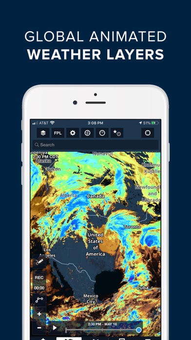
US Lowest-Tilt Radar Map Layer
• See where precipitation is likely reaching the ground with the return of this popular map layer sporting lower latency and improved spatial resolution.
• The Radar (Lowest-Tilt) layer only depicts radar returns obtained at the lowest angle of the radar’s sweep, which better correspond to where precipitation is reaching the ground in the form of rain or snow.
• The new layer benefits from significantly reduced latency of 6 minutes or less and also provides enhanced spatial resolution, although the layer doesn’t yet support storm track markers.
• The Radar (Lowest-Tilt) layer is currently limited to the US and South Korea.
Runway Analysis: Landing Factor Selector
• Separately calculate a flight’s landing distance during pre-flight planning and before arrival to better comply with your SOP and industry guidance on mitigating runway excursions.
• While in the Landing Analysis or Emergency Return views, tap either the Surface Condition or Landing Factor fields to access the new Landing Factor Selector.
• Select either Pre-Flight / Dispatch or In-Flight / LDTA under Phase of Flight to access different options for surface condition and landing factor, with the latter also supporting runway condition codes in place of actual surface conditions.
• Selecting different surface conditions in either mode will also automatically filter the list of available landing factors, which are more clearly labeled with both percentage and factor multiplication equivalents.
• Additional settings related to landing factor selection are also available in More > Aircraft > Field Performance > Landing
• Available with ForeFlight’s Runway Analysis add-on for supported jet and select turboprop aircraft.
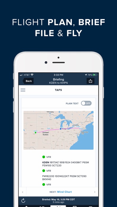
Runway Analysis: TOLD Card
• Brief your takeoff or landing with a clean and printer-friendly summary of the most critical pieces of information produced by Runway Analysis.
• In the Takeoff or Landing Analysis views, tap the new TOLD button next to the Summary button in the upper-right corner to view the TOLD card, and tap the Send To button in the top-right to share or print it.
• Available with ForeFlight’s Runway Analysis add-on for supported jet and select turboprop aircraft.
|
5つ星
5
4つ星
3
3つ星
0
2つ星
0
1つ星
1
|
ForeFlight Mobile EFBのiPhoneアプリランキングや、利用者のリアルな声や国内や海外のSNSやインターネットでの人気状況を分析しています。
|
|
※この結果はForeFlight Mobile EFBのユーザー解析データに基づいています。
1位: Basic Plus US - 1 Year (18000円)
2位: Basic Plus US - 3 months (9000円)
3位: Basic Plus APAC - 1 Year (18000円)
4位: Pro Plus US - 1 Year (35000円)
5位: Performance Plus US - 1 Year (50000円)
6位: Basic Plus APAC - 3 Months (9000円)
7位: Pro Plus APAC - 1 Year (35000円)
8位: Performance Plus APAC - 1 Year (50000円)
9位: Performance Plus US - 1 Year (50000円)
10位: Performance Plus APAC - 1 Year (50000円)
![]()
・・・だが断るッ!!
※デモグラフィックデータを元にユーザー層の性別や年齢分布などを考慮して推定しています。

¥2,800→¥2,280 : 腐敗した帝国に対抗するために結成された義賊団となり、ターン毎にカードを選び、行動選択と陣形で敵と戦う、タクティクスファンタジーRPGのHDリマスター版『ブレイズ・ユニオン Blaze Union』が期間限定値下げ!
2024年04月25日 23:25

¥2,600→¥2,000 : ジョブチェンジシステムなど自由度の高いシステムで、光の戦士の物語を描いたFF5のピクセルリマスター版『FINAL FANTASY V』が期間限定値下げ!
2024年04月25日 20:25

魔法使いとなり、島を探索しながら開拓しむらを作り上げていく、農園箱庭シミュレーションゲーム『ミラクルハウス』が面白いと人気が出始めている模様
2024年04月25日 16:00

閉じ込められた雪山のコテージから抜け出す、謎解き脱出ゲーム『雪山のコテージからの脱出』へのアクセス利用数が伸びる
2024年04月25日 13:00

月を舞台に犬が、不思議な生きものたちと出会いながら、人類の歴史に迫るアドベンチャーゲーム『Doggins』がネットで取り上げられ話題に
2024年04月23日 20:00