アプリオンは、世界のアプリランキングや口コミから、おすすめアプリをまとめている人気アプリ探しサイトです。

Air Navigation Pro [iPhone]

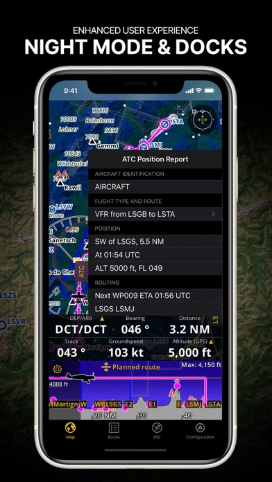
Xample Sarlが配信するiPhoneアプリ「Air Navigation Pro」の評価や口コミやランキング推移情報です。このアプリには「ナビゲーション」「旅行」などのジャンルで分類しています。APPLIONでは「Air Navigation Pro」の他にもあなたにおすすめのアプリのレビューやみんなの評価や世界ランキングなどから探すことができます。

Air Navigation Pro

無料  iPhone対応 WiFiダウンロード ナビゲーション 旅行 64bit 4.6 売上順位:ナビゲーション 40位 (iPhone)

88
Trend
Air Navigation Proのおすすめ画像1
Air Navigation Proのおすすめ画像2
Air Navigation Proのおすすめ画像3
Air Navigation Proのおすすめ画像4
Air Navigation Proのおすすめ画像5
Air Navigation Proのおすすめ画像6
Air Navigation Proのおすすめ画像7
Air Navigation Proのおすすめ画像8
Air Navigation Proのおすすめ画像9
Air Navigation Proのおすすめ画像10
<
>

Xample Sarlの地図/ナビアプリ

「Air Navigation Pro」は、Xample Sarlが配信する地図/ナビアプリです。

ナビゲーション 旅行

このアプリの話題とニュース

  • レビュースコア4.5をマークしている高評価の優良アプリです。(4/24)


  • 100人を超える、評価・クチコミ投稿者数となっています。(4/24)


  • 新バージョン8.3.370が配信開始。新機能や改善アップデートがされています。(4/18)


  • 2009年1月8日(木)にiPhone版がリリース!


このレビュアーのおすすめコメント

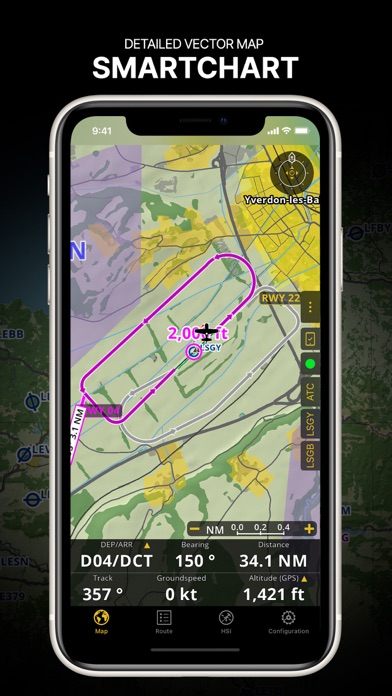
HSI、ADF,CDI、ALT、すべり計を模擬したアプリです。
GPSから自分の位置情報を得て、データベースにあるウェイポイントの中から任意のウェイポイントを選択すると、HSIのベアリングポインターやADFが指示しますし、HSIのコースインジケーターもフリックしてベアリングを設定すると、ちゃんとデビエーションバーが指示します。
ナビゲーションの参考機器として使えます - ★★★★★
エラーが発生してログインできなくなりサポートに問い合わせたところ、とても親身に対応いただきました。
ありがとうございました。
使用感も問題なく普段のフライトにとても役立っております。
英語がある程度使えないと難しいかもしれませんが、きっとまた親切に対応してくれると思います。
サポートセンターの対応 - ★★★★★
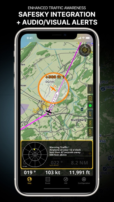
フライト時のナビゲーションを簡単操作で素早く正確にサポートしてくれます。
フライトログやフライトレコーダー機能があり、フライトコースのみならず、高度情報やヘディングまできろされ、保存されます。
その他多様な機能があり、もはやフライトの必需品となっています。
素晴らしいパイロットサポーターです - ★★★★★

最新更新情報

version8.3.370が、2024年4月18日(木)にリリース

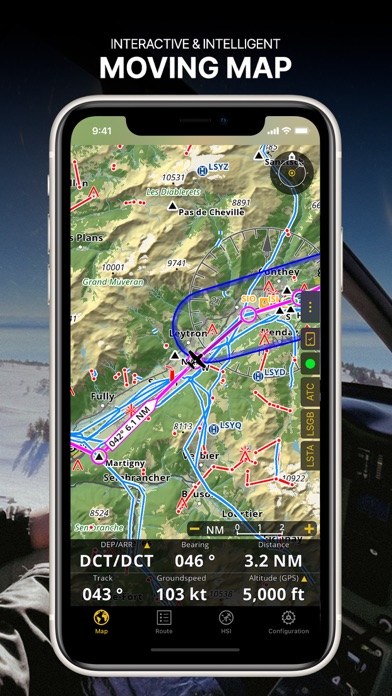
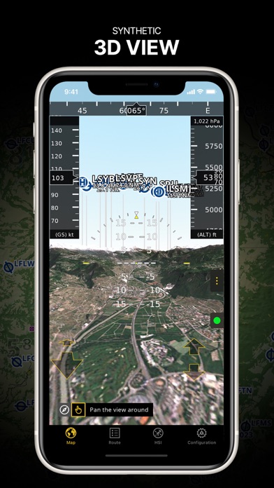
- Introducing Synthetic View: Our 3D View has received an upgrade with an improved UI and an integrated Moving Map preview!
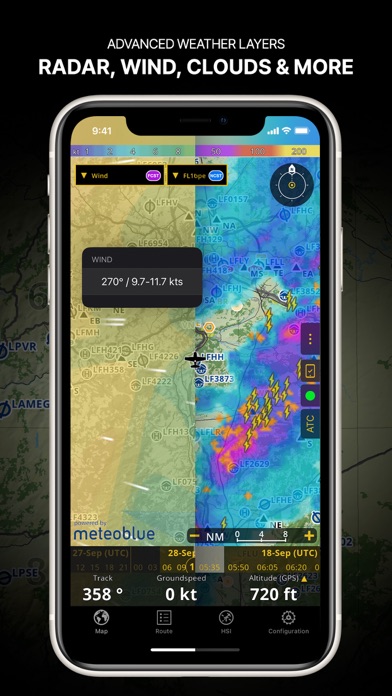
- New Map Visibility Settings: Take control of overlapping maps by setting custom zoom level ranges, ensuring smooth transitions while zooming in and out.
- Enhanced Satellite Imagery: Smart Advanced subscribers now enjoy high-quality satellite views at higher zoom levels, while all other Smart plans gain access to regional topographical and satellite tile servers like Swisstopo, IGN, etc. Visit the Map Store to activate them for free!

使い方や遊び方

Discover our flight planning & real-time navigation app for free for 28 days!
- Everything you need to fly around the world
- Plan your flight in a few minutes
- Fly relaxed with up-to-date information


Air Navigation Pro is a high-quality flight assistant app for pilots worldwide. Benefit from the following main features:


MOVING MAP
Plan and navigate using our interactive moving map. Choose between aeronautical charts, satellite or our vector map as a background. On top of that, the moving map displays waypoints, NOTAM, obstacles and airspaces from our comprehensive, always up-to-date worldwide aeronautical database. Tap on any waypoint directly on the map to easily create a route. Personalize the values shown on the navbar to have exactly the information you need: altitude, vertical speed, bearing, distance to the next waypoint, ETA calculations, etc. Choose the airport departure and arrival procedures for your route to have them also displayed on top of the moving map.


ENHANCED TRAFFIC AWARENESS
Get visual and audio alerts in all languages for nearby conflicting traffic. Choose your preferred traffic icon between generic, aircraft or TCAS symbols. Your safety is important to us, which is why we partnered with SafeSky to ensure our users have live traffic data during their flight. Benefit from the native integration with SafeSky included in our new Smart Lite, Smart Classic and Smart Advanced subscriptions—a two-in-one package!


ADVANCED WEATHER LAYERS
In addition to the basic weather reports & forecast of winds, TAF and METAR for your flight, subscribers of the Smart Advanced plan can activate see-through weather layers on top of the moving map. Available layers include rain radar, wind, pressure, clouds and rain, visibility, gust and for Germany, Switzerland, Austria and the Balkans, we also have GAFOR. Tap on any point on the map to see the weather information for that area. Review the weather forecast for up to three days ahead.


NOTAM
After creating your route, set the departure time in the future to have the moving map display the NOTAM active for that specific time. NOTAM on the map change color dynamically based on their status.


SMARTCHART
Our cutting-edge SmartChart is a highly detailed and intelligent vector-based map that adapts to your needs, providing you with adequate information at any zoom level. The SmartChart optimizes the display of shadows to easily distinguish between valleys and mountains, and the text remains perfectly aligned, guaranteeing optimal readability. Including the latest significant improvements with forests and detailed airport information.


ELEVATION PROFILE & SYNTHETIC VIEW
Enable the profile view below the navbar for enhanced situational awareness of the elevation ahead of you or along your route. Choose the corridor width between 0 to 5 NM and overlay options: airspaces, NOTAM, obstacles, wind components, populated places, etc. Switch to the synthetic view for additional terrain information, plus an artificial horizon with altitude and vertical speed indicators. This function can also be used to pan around while preparing for your flight. Activate TAWS on the moving map as well as on the synthetic view.


AERONAUTICAL CHARTS & APPROACH CHARTS
We offer the most extensive worldwide catalog of aeronautical charts, including the ICAO charts. Have the georeferenced approach charts displayed on top of the moving map or the 3D view.


BRIEFING
Prepare your flight with our briefing section by creating documents with NOTAM and weather charts & stations relevant to your planned route. Optimize time by creating an aircraft profile which will be used in the Briefing section to pre-fill for you the ATC Flight Plan and calculate the W&B.


AND SO MUCH MORE!


Please note that WiFi-only devices do not include an internal GPS receptor; for these devices, an external sensor is required. Refer to our user manual on our website: www.airnavigation.aero for more information.

紹介ムービー&プレイ動画

Introducing Air Navigation Pro Android, a modern, intuitive and visual application for your VFR flying experience.


AIR NAVIGATION PRO - FLIGHT PLANNING APPLICATION HD

カスタマーレビュー・評価

4.6
5つ星
 
128
4つ星
 
33
3つ星
 
14
2つ星
 
1
1つ星
 
3

おすすめ口コミ

good for us

It's very good for pv pilot safty navigation.
on aircraft instrument very old.
We don't no so good thing in APP STORE
now i'm fling PA46marib G-1000 air craft it's same as airnavigation PRO data

hiro135 - ★★★★★ 2014-02-10

便利!

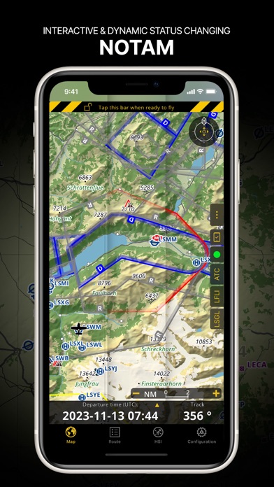
非常に便利です。周波数なんかも空港をタップするだけで出てくるのはかなり良いです。ただ日本の空域も表示しないのが残念です。
精度はかなり良く、RNAVならぬiNAVが出来るのではと思うほどです。今後の空域表示も期待して、星4つにきておきます。

ATCだいすき。 - ★★★★★ 2015-09-27

日本の空も

せめて情報圏、菅制圏はあった方がいいな。あとスケールが自由に動かせて二本の指で拡大、縮小ができたらな。菅制区の近くに行く事があるので四角や丸を描けるエディタ機能もお願いします。ヾ(@⌒ー⌒@)ノ

RC.Pro - ★★★★★ 2011-12-15

Correction request

I think this app is very helpful tool for me, but I'd like to correct one thing.
JP-0002 is not Tokyo heliport.
This is Urayasu heliport of PV.
Correct position is N35°38'10" ,E139°50'22".

R44nini - ★★★★★ 2013-10-25

素晴らしい

専用の航空機GPS並みの技能で、使い方は簡単。チャートや地形のモニターも世界中の物を購入できる。

マスミヨシ - ★★★★★ 2018-12-15

大空の安全 safety for sky

昔からあれば、良かった優れもの、

Gamin1000データーと同一

800万と、Nav Pro

Hiro EC135 - ★★★★★ 2018-12-29

最新ストアランキングと月間ランキング推移

Air Navigation ProのiPhoneアプリランキングや、利用者のリアルな声や国内や海外のSNSやインターネットでの人気状況を分析しています。

基本情報

仕様・スペック

対応OS
13.0 以降
容量
204 M
推奨年齢
全年齢
アプリ内課金
あり
更新日
2024/04/18

リリース日
2009/01/08

集客動向・アクティブユーザー分析

オーガニック流入


アクティブ率


※この結果はAir Navigation Proのユーザー解析データに基づいています。

アプリ内課金の売れ筋ランキング

  • 1位: SMART (8800円)

  • 2位: Aeronautical database (10000円)

  • 3位: Japan - Whole country 3D data (4000円)

  • 4位: Smart - Asia (8700円)

  • 5位: Smart Plus - Asia (11200円)

  • 6位: Essential worldwide (8700円)

  • 7位: Japan - VFR 500k AIS 2022 (6000円)

  • 8位: Smart Lite (20000円)

  • 9位: Smart Advanced (30000円)

  • 10位: Japan - VFR 250k AIS 2022 (4500円)

利用者の属性・世代

アプリ解析デモグラフィックデータ(男女年代比率52%)

あると思いますっ!

デモグラフィックデータを元にユーザー層の性別や年齢分布などを考慮して推定しています。

ネット話題指数

開発会社の配信タイトル

このアプリと同一カテゴリのランキング

龍が如く8 (PS4)
セガ
amazon

新着おすすめアプリ

新着おすすめアプリ >

注目まとめ

iPhoneアプリまとめ >

ダウンロード数が多いおすすめアプリ

無料ゲームアプリランキング >