アプリオンは、世界のアプリランキングや口コミから、おすすめアプリをまとめている人気アプリ探しサイトです。

OS Maps: Walking & Bike Trails [iPad]

OS Maps: Walking & Bike Trails

無料  iPhone / iPad対応 WiFiダウンロード ナビゲーション ヘルスケア/フィットネス 64bit 3.5 売上順位:ナビゲーション 156位 (iPad)

82
Trend
  • 入賞・受賞歴 月間ナビゲーション部門最高ランキング 110位を獲得!(4/5)
OS Maps: Walking & Bike Trailsのおすすめ画像1
OS Maps: Walking & Bike Trailsのおすすめ画像2
OS Maps: Walking & Bike Trailsのおすすめ画像3
OS Maps: Walking & Bike Trailsのおすすめ画像4
OS Maps: Walking & Bike Trailsのおすすめ画像5
OS Maps: Walking & Bike Trailsのおすすめ画像6
OS Maps: Walking & Bike Trailsのおすすめ画像7
OS Maps: Walking & Bike Trailsのおすすめ画像8
OS Maps: Walking & Bike Trailsのおすすめ画像9
OS Maps: Walking & Bike Trailsのおすすめ画像10
<
>

Ordnance Surveyの地図/ナビアプリ

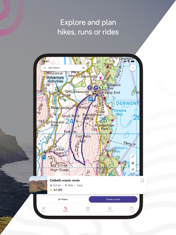
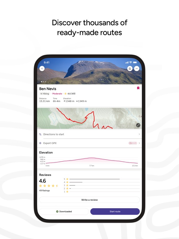
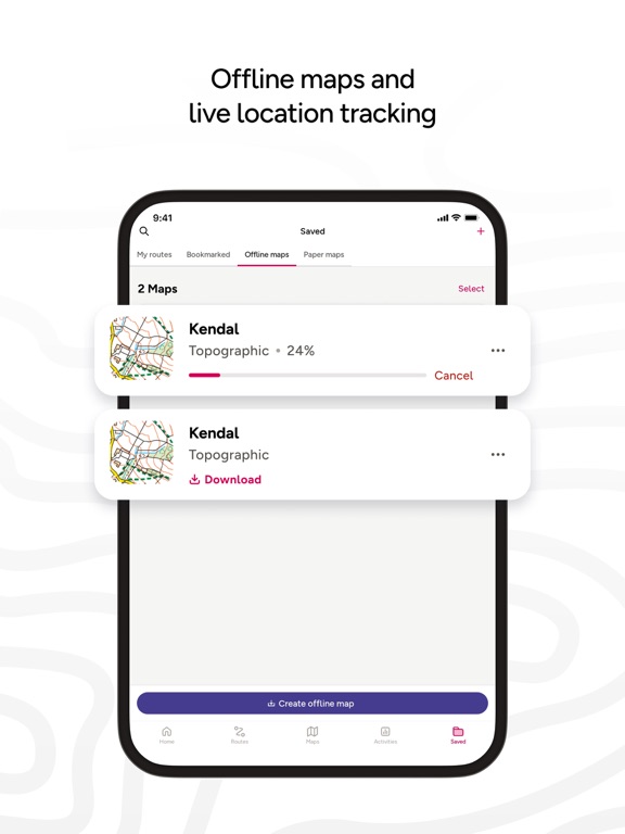
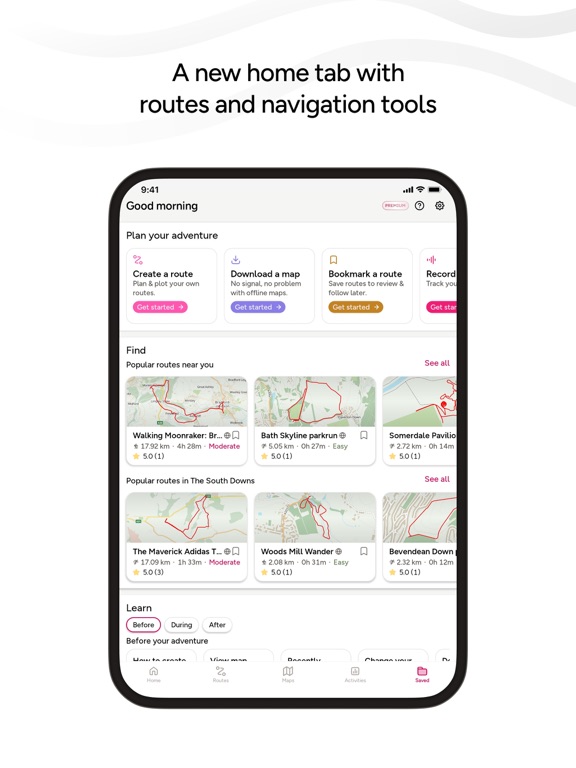
「OS Maps: Walking & Bike Trails」は、Ordnance Surveyが配信する地図/ナビアプリです。

ナビゲーション ヘルスケア/フィットネス

このアプリの話題とニュース

  • 新バージョン5.0.6が配信開始。新機能や改善アップデートがされています。(4/17)


  • 2015年6月11日(木)にiPhoneとiPad両対応のユニバーサルアプリとしてリリース!


最新更新情報

version5.0.6が、2024年4月17日(水)にリリース

This latest release addresses minor bugs such as improvements to exporting a route on iPad.

使い方や遊び方

Create your adventures your way & let OS Maps guide you on stunning routes across the UK & beyond. Get more from the outdoors, with more freedom to explore, more confidence to tackle that next challenge & more adventures along the way. OS Maps is the official app by Ordnance Survey & your guide in the great outdoors.

Why you’ll love using OS Maps:

EXPLORE & PLAN HIKES, RUNS OR RIDES
Whether you are planning a walk, hike, run or ride; OS Maps lets you create outdoor adventures with trusted mapping & navigation tools from the experts at Ordnance Survey, Britain’s national mapping service.

DISCOVER THOUSANDS OF READY-MADE ROUTES
Get outside with curated routes from outdoor experts & organisations such as Trail, Country Walking, Mountain Bike UK, BBC Countryfile & more.

ICONIC OS MAPPING
Subscribe to unlock the detail & accuracy of OS leisure maps including OS Explorer 1:25,000 & OS Landranger 1:50,000 & now with global mapping & topographic mapping for USA, Australia & New Zealand to keep you exploring all over the world.

CREATE YOUR OWN ADVENTURES
Best in class route planning & navigation tools mean you can get off the beaten track & explore with more freedom. Plan routes with quick & easy snap-to-path route plotting, then save & share with your friends to plan that next epic day in the outdoors.

NO SIGNAL? NO PROBLEM
Download maps & routes to your phone to view offline, so they’re ready, whenever & wherever you need them. View any part of GB even without signal & export to your GPS device.

UNLIMITED PRINTING
Print copies of all your routes & maps to take with you, so you always have a backup to hand.

USE ON EVERY DEVICE
Sync your activities between across devices, on desktop, mobile & Apple Watch. On desktop, premium users can use our 3D Aerial Layer & route fly-throughs to see the landscape, terrain & explore in stunning 3D.

TRACK & RECORD ACTIVITIES
Use the activity recording feature to keep a log of your activity history. Follow along, save your activity, review it & turn it into a new route to share & follow again later.

RECOMMENDED BY THE EXPERTS
Ordnance Survey is proud to partner with Mountain Rescue England & Wales, with OS Maps as their recommended app to help you keep on track, & keep safe when heading outside.

TABLETOP 3D
Preview a route before you tackle it, ensure it’s suitable for your level of fitness & avoid any surprises. Our 3D model feature lets you check out your routes from the comfort of your home.

SUBSCRIPTION INFORMATION
OS Maps premium is available through a 1 month or 1 year subscription. Prices are posted in GBP but may vary by country or when converted to local currency. Subscriptions will auto-renew. Payment will be charged to iTunes Account at confirmation of purchase. The subscription automatically renews unless auto-renew is turned off at least 24-hours before the end of the current period. Your account will be charged for renewal within 24-hours prior to the end of the current period, & identify the cost of the renewal. Subscriptions may be managed by the user & auto-renewal may be turned off by going to the user's Account Settings after purchase.
Terms & Conditions at os.uk/termsosmaps

USEFUL INFORMATION
Battery life while using the app can be extended downloading maps offline prior to use, operating in Flight Mode (the GPS will still work) & turning off the screen when not in use. We release updates to all of our apps on an ongoing basis to improve stability & add extra features. Topographic mapping is available for UK (including Northern Ireland), USA, Australia & New Zealand. Your feedback & comments about this app are important to us. Leave a review or use os.uk/contact to get in touch.
*This feature uses Apple's ARKit which requires an iPhone 6s, iPhone SE, iPad 2017, iPad Pro or any later device.

カスタマーレビュー・評価

3.5
5つ星
 
0
4つ星
 
1
3つ星
 
1
2つ星
 
0
1つ星
 
0

最新ストアランキングと月間ランキング推移

OS Maps: Walking & Bike TrailsのiPadアプリランキングや、利用者のリアルな声や国内や海外のSNSやインターネットでの人気状況を分析しています。

基本情報

仕様・スペック

対応OS
15.0 以降
容量
111 M
推奨年齢
全年齢
アプリ内課金
あり
更新日
2024/04/17

リリース日
2015/06/11

集客動向・アクティブユーザー分析

オーガニック流入


アクティブ率


※この結果はOS Maps: Walking & Bike Trailsのユーザー解析データに基づいています。

アプリ内課金の売れ筋ランキング

  • 1位: 1 month (650円)

  • 2位: 12 months (3900円)

利用者の属性・世代

アプリ解析デモグラフィックデータ(男女年代比率52%)

いつやるの?今でしょ!

デモグラフィックデータを元にユーザー層の性別や年齢分布などを考慮して推定しています。

ネット話題指数

開発会社の配信タイトル

このアプリと同一カテゴリのランキング

のっけるふりかけ 鮭明太
丸美屋
amazon

新着おすすめアプリ

新着おすすめアプリ >

注目まとめ

iPadアプリまとめ >

ダウンロード数が多いおすすめアプリ

無料ゲームアプリランキング >