アプリオンは、世界のアプリランキングや口コミから、おすすめアプリをまとめている人気アプリ探しサイトです。

SkyDemon [iPad]

  • 入賞・受賞歴 月間ナビゲーション部門最高ランキング 140位を獲得!(4/11)
SkyDemonのおすすめ画像1
SkyDemonのおすすめ画像2
SkyDemonのおすすめ画像3
SkyDemonのおすすめ画像4
<
>

Divelements Limitedの地図/ナビアプリ

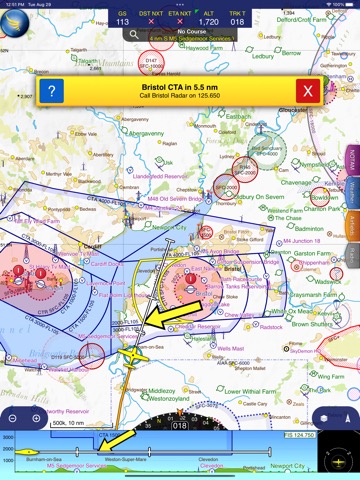
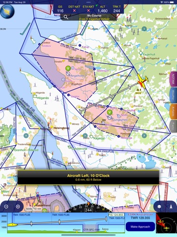
「SkyDemon」は、Divelements Limitedが配信する地図/ナビアプリです。

ナビゲーション

このアプリの話題とニュース

  • 新バージョン3.16.13が配信開始。新機能や改善アップデートがされています。(4/1)


  • 2012年2月10日(金)にiPhoneとiPad両対応のユニバーサルアプリとしてリリース!


最新更新情報

version3.16.13が、2024年4月1日(月)にリリース

- The new Explore Heatmap tool allows you to create and explore heatmaps from all your logged flights
- Many improvements to memory consumption, speed of loading data and speed of drawing maps

使い方や遊び方

SkyDemon is Europe's favourite software for VFR flight planning and in-flight navigation.


Use this app to access your SkyDemon subscription on your iOS device, unlocking SkyDemon's powerful features while on the move.


FLIGHT PLANNING FEATURES


- SkyDemon vector charts are the clearest aeronautical charts you'll ever use, with dynamic airspace clipping and choice of map layers
- Route planning is as simple as touching consecutive waypoints and dragging to make changes
- Virtual Radar shows how your route relates to airspace, terrain, obstructions and other features
- Pilot Log facility calculates headings and groundspeeds from actual wind data, and shows useful frequencies
- Plates and other documents for relevant airfields are displayed automatically as you plan, and many are available georeferenced for use in flight
- Intuitive pan, pinch and rotate support with no loss of map clarity or text legibility
- File a VFR flightplan for your route directly to air traffic controllers
- Automatic TAF, METAR and SIGMET briefing as you plan a route, with graphical decoding
- Rainfall data can be overlaid on the main map, with animation, showing the trend of rainfall over time
- Integration of GAFOR route forecasts for Switzerland, Austria, Slovenia and Croatia
- Both narrow-route and area NOTAM briefings available, updated as you plan
- Advanced NOTAM graphical interpretation and depiction on the main map
- Easily print your PLOG and the output from various briefings
- Warnings for airspace and other potential hazards to your flight, updated in real time
- Airfield Admin Information shows useful contacts and other details for airfields featured in our charts
- Forecast winds aloft are automatically retrieved for the flight time and displayed on the map
- Create an advanced flight performance profile for each aircraft you use
- ATS Routes mode offers an alternative chart presentation for flight along airways
- Accurate fuel, weight and balance calculations including flight costings
- Create an unlimited number of user-defined waypoints
- Analyse your track logs for posterity
- Choose between six different vector chart styles
- Extensive European chart coverage as standard


GPS NAVIGATION FEATURES


- Intelligent warnings for approaching airspace, NOTAM, obstacles, terrain and other hazards
- Virtual Radar shows a side-on projection of all approaching features and how your trajectory relates to them
- Vector map automatically follows the aircraft in north up, track up or course up orientation
- Clear and concise instruments show you flight statistics and help keep you on track
- An HSI/ILS instrument helps you keep to your planned route and line up early for approach
- Live Pilot Log shows progress through your route, ETAs, ATAs and useful frequencies based on your current position
- TerrainSafe dynamically colours mountainous terrain around you to quickly identify safer areas
- Direct To allows easy re-routing in a hurry by picking from a selection of nearby airfields
- Approach Information shows runway diagrams, TAF, METAR, NOTAM and other airfield details useful for making an approach
- Live updates of TAF and METAR while in flight, with associated alerts*
- Extended runway centrelines appear automatically on the map as you near your destination airfield
- Permanent display of position relative to nearest well-known waypoint, for position reporting
- Easy changing of the planned route while in flight by touching and dragging


Continued use of GPS running in the background can dramatically decrease battery life.


* Internet connection required for live weather update while in flight

カスタマーレビュー・評価

5.0
5つ星
 
3
4つ星
 
0
3つ星
 
0
2つ星
 
0
1つ星
 
0

最新ストアランキングと月間ランキング推移

SkyDemonのiPadアプリランキングや、利用者のリアルな声や国内や海外のSNSやインターネットでの人気状況を分析しています。

基本情報

仕様・スペック

対応OS
10.0 以降
容量
49.2 M
推奨年齢
12歳以上
アプリ内課金
あり
更新日
2024/04/01

リリース日
2012/02/10

集客動向・アクティブユーザー分析

オーガニック流入


アクティブ率


※この結果はSkyDemonのユーザー解析データに基づいています。

アプリ内課金の売れ筋ランキング

  • 1位: SkyDemon iOS Subscription (30000円)

利用者の属性・世代

アプリ解析デモグラフィックデータ(男女年代比率52%)

あれ、声が、遅れて、聞こえるよ。

デモグラフィックデータを元にユーザー層の性別や年齢分布などを考慮して推定しています。

ネット話題指数

開発会社の配信タイトル

このアプリと同一カテゴリのランキング

ファイティングスティックα (PS5,PS4,PC)
HORI
amazon

新着おすすめアプリ

新着おすすめアプリ >

注目まとめ

iPadアプリまとめ >

ダウンロード数が多いおすすめアプリ

無料ゲームアプリランキング >